
Page 427 - Automotive Engineering Powertrain Chassis System and Vehicle Body
P. 427
CHAP TER 1 4. 1 Global positioning technology
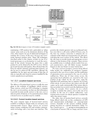
Fig. 14.1-10 Block diagram of basic GPS-enabled navigation system.
maintaining a GPS position lock, particularly in ‘urban provides the vehicle operator with an on-demand wire-
canyon’ areas such as in the downtown districts of big less voice link to a call centre staffed 24 hours a day. At
cities, often require the use of additional techniques to the time the wireless connection is initiated, the co-
maintain the accuracy of the user’s location and move- ordinates of the vehicle are transmitted to the call centre,
ments between position locks. These DR techniques, indicating the exact position of the vehicle. This allows
described earlier in this chapter, include the use of in- the call centre to provide timely and appropriate services
ternal gyroscopes or accelerometers to track the move- relevant to the location of the customer. These services
ment of the vehicle between the times that a solid are available today in multiple vehicle models from sev-
position fix can be obtained by the GPS receiver. Vehicle eral manufacturers, and will likely become standard
speed and direction information, often obtained directly features in the near future on many vehicle lines.
from the vehicle’s internal communication network, can The most common emergency services being offered
also be used to enhanced DR capabilities, although the today include the notification of emergency response
capabilities for the input and processing of this type of personnel in the case of an accident, and the notification
data arc typically only found in systems installed by the of automotive service personnel in the case of a vehicle
vehicle manufacturers and dealers. malfunction. When one of these events occurs, the
appropriate local authorities are vectored to the exact
position of the vehicle by the call centre, using the
14.1.5.2 Location-based services uploaded GPS positioning data to pinpoint the location
of the vehicle. In some systems, the contact with the call
The delivery of location-based services is really the next centre can be made automatically if the system detects
phase in the evolution of intelligent vehicle systems. that an incident has occurred, upon the deployment of an
These services, which use GPS technology to pinpoint airbag, for example. Other systems rely on a vehicle
the user’s current position, can then use that information occupant to initiate the contact, even in the case of an
to provide location-specific services to the user, such as accident. In the case of a vehicle malfunction, most
relevant points of interest, or the nearest locations where systems today require the vehicle operator to initiate the
a desired service or product may be available.
call to the service centre.
The other class of location-based services currently
14.1.5.2.1 Current location-based services
being offered which rely on this combination of GPS
The most common types of location-based services and communication technologies are concierge/assist
available in intelligent vehicles today are emergency and services. Examples of the services available include:
concierge/assist services. These services are accessed getting directions to a desired destination (‘Help, I’m
using a system combining GPS and wireless communi- lost, I need to get to . . .’) , getting recommendations on
cation technology with a very basic user interface. This a local point of interest (‘We are hungry and don’t know
434