
Page 426 - Automotive Engineering Powertrain Chassis System and Vehicle Body
P. 426
Global positioning technology C HAPTER 14.1
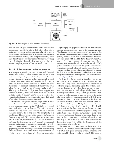
Fig. 14.1-9 Block diagram of basic handheld GPS device.
location onto a map of the local area. These devices may a larger display can graphically indicate the user’s current
also provide the ability to enter in destination information, position superimposed on a map of the surrounding area.
so the user can more easily understand where they are in Also, because these systems are typically mounted in the
relation to where they want to be. However, most of these dashboard, displacing the existing vehicle entertainment
devices fall short of being true navigation systems, since system, many of them include entertainment function-
they do not provide any assistance to the user in reaching ality such as an AM and FM stereo tuner or audio CD
their destination. Instead, they simply give the user player. The more advanced systems with direct
a more complete picture of their current location. interconnections into the vehicle may also include HVAC
system controls or other vehicle-specific comfort and
convenience controls, although this is usually limited to
14.1.5.1.2 Autonomous navigation systems systems installed by the vehicle manufacturer or dealer.
True navigation, which provides the user with detailed An illustration of the functional blocks of an autonomous
instructions on how to reach a specific destination, is one navigation system with an integrated GPS receiver can be
of the fastest-growing areas in intelligent vehicle tech- seen in Fig. 14.1-10.
nology. Navigation devices utilize map-matching and To determine the appropriate travelling instructions
best-path algorithms, along with user-defined filtering, to with one of these devices, the user enters the desired
allow the user to choose between the fastest or most destination using a menu-driven system via a hardware or
direct route to a desired destination. Some systems even software keypad, depending upon the system. Some
allow the user to indicate specific routes to be avoided. systems also support voice-based destination entry using
The map databases used all provide basic mapping in- basic voice-recognition technology. While these voice-
formation (streets, major landmarks, etc.), but can also driven systems are becoming more sophisticated, much
include points of interest and/or helpful location in- progress is still necessary to improve them to the point
formation (restaurants, etc.), depending upon their level where non-technical users are satisfied with their accu-
of detail and how often they are revised. racy and reliability. The methods in which the directions
Autonomous navigation devices range from in-dash are communicated to the user also depend upon the
units that are small enough to fit into a 1-DIN slot, to complexity of the system. Navigation systems with lim-
multi-component systems with CD-ROM changers and ited displays may use simple graphics combined with
large multi-plane colour displays. The price of these text to indicate the directions in a turn-by-turn manner.
systems can vary from a few hundred dollars to several Some systems may combine these graphical turn-by-turn
thousand dollars, depending upon the complexity and instructions with spoken instructions, using text-
capabilities. These systems utilize position information to-speech technology. Systems with larger displays can
from an integrated GPS receiver, along with map data- indicate the current position and immediate directions
base information provided from a CD-ROM or memory on a map of the immediate area, as well as the desired
cartridge, to determine the user’s current geographical destination, once it is within the boundaries of the
location on the map. The smaller, in-dash units typically current map being displayed.
have a limited ability to display the user’s position The value of GPS technology to these systems is
graphically, instead indicating the current location using obvious. GPS provides the essential positioning elements
a text description, such as the current address or location of location and speed necessary to make dynamic navi-
relative to a near-by landmark. Systems supporting gation possible. However, the occasional difficulties in
433