
Page 129 - Carbonate Sedimentology and Sequence Stratigraphy
P. 129
120 WOLFGANG SCHLAGER
A quantitative flow model by H. Kooi (Vrije Univ. Ams- Another mechanism of stress increase has gained support
terdam) indicates that under these circumstances, platform from recent studies of carbonate slopes - added stress by
rocks are very unlikely to preserve significant overpressures sediment loading. Spence and Tucker (1997) rightly point
during sea-level falls. Efficient flushing of the Pleistocene out that in detrital sediments at the angle of repose stress
platform rocks of the Bahamas is confirmed by the observa- will not increase by addition of sediment. The situation is
tion that borehole Unda, 10 km inboard of the platform mar- different, however, for in-situ growth of rigid bodies such as
gin, presently is charged with well-mixed seawater down to reefs or bodies of automicrite (see chapter 2). Several au-
about 200 m (Swart et al., 2001). thors have observed that substantial volumes of automicrite
Slope deposits of Great Bahama Bank present a some- in the form of layers, lenses or mounds have been added
what different picture. They have permeabilities of > 100 to the slopes of the T and M factories by in-situ precipita-
millidarcy separated by cemented layers of 0.01 millidarcy tion (Playford, 1980; Brandner et al., 1991; Blendinger, 1994;
or less (Kenter et al., 2001; Melim et al., 2001). This configu- Wood, 1999; Blendinger, 2001; Keim and Schlager, 2001).
ration offers possibilities for preserving overpressure if the These bodies are rigid upon formation and represent lo-
tight layers are extensive and laterally continuous, some- calized loads that may be capable of triggering slides and
thing that is not known at present. Local sealing potential slumps (Fig. 7.19). The common occurrence of automicrite
of deeper-water carbonates was recently confirmed by ex- and marine cement in megabreccia boulders certainly sug-
tremely low permeabilities measured on North-Sea chalks gests a connection.
(Mallon et al., 2005). However, it is also well established that In summary, the evaluation of processes that can trig-
the same chalks generally are in hydrostatic equilibrium in ger large slides, slumps and debris flows does not, at this
the upper 1,000 m or more of the rock column (Scholle et al., point, provide convincing arguments for sea-level falls as
1983, p. 619). the prime driver of megabreccia formation. Without further
information, megabreccias should not be considered as in-
dicative of a particular sea-level position. Whether there is a
Stress increase in the rock fabric. Spence and Tucker (1997)
specific connection in a particular instance, needs to be de-
propose that stress increase by loss of buoyancy during sea-
termined in a case study. Ineson and Surlyk (2000) have con-
level falls may lead to slope failure at the platform margins. tributed an important example of this kind. Based on strong
This is a distinct possibility. Whether it is a common phe- circumstantial evidence the megabreccias of their Cambrian
nomenon remains to be seen. The large number of near- example were associated with highstands and lowstands
vertical sea cliffs in Quaternary limestones suggests that in but the largest and most extensive ones occurred during
many instances meteoric lithification strengthens the rock lowstands.
faster than the increase of apparent weight by sea-level fall
can crush it.
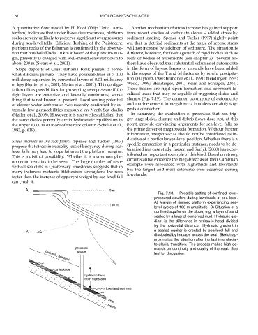
A) 0 m
Fig. 7.18.— Possible setting of confined, over-
pressured aquifers during lowstands of sea level.
A) Margin of rimmed platform experiencing sea-
-100 m
level cycles of 100 m amplitude. B) Situation of a
confined aquifer on the slope, e.g. a layer of sand
sealed by a layer of cemented mud. Hydraulic gra-
dient is the difference in hydraulic head divided
by the horizontal distance. Hydraulic gradient in
B) a sealed aquifer is created by sea-level fall and
dissipated by leakage across the seal. Sketch ap-
proximates the situation after the last interglacial-
to-glacial transition. The process makes high de-
pressure mands on continuity and quality of the seal. See
gauge
text for discussion.
hydraulic gradient
leakage
hydraulic head
from highstand
lowstand sea level
seal
aquifer