Page 151 - Carbonate Sedimentology and Sequence Stratigraphy
P. 151

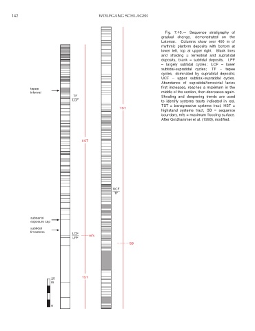
142                                      WOLFGANG SCHLAGER


                                                                                Fig. 7.45.— Sequence stratigraphy of
                                                                              gradual change,  demonstrated on  the
                                                                              Latemar.  Columns show over 400 m of
                                                                              rhythmic platform deposits with bottom at
                                                                              lower left, top at upper right.  Black lines
                                                                              and shading = terrestrial and supratidal
                                                                              deposits, blank = subtidal deposits.  LPF
                                                                              – largely subtidal cycles;  LCF – lower
                                                                              subtidal-supratidal cycles;  TF – tepee
                                                                              cycles, dominated by supratidal deposits;
                                                                              UCF – upper subtidal-supratidal cycles.
                                                                              Abundance of supratidal/terrestrial facies
                                                                              first increases, reaches a maximum in the
                tepee
                interval                                                      middle of the section, then decreases again.
                                    TF                                        Shoaling and deepening trends are used
                                    LCF                                       to identify systems tracts indicated in red.
                                                                              TST = transgressive systems tract, HST =
                                                          TST
                                                                              highstand systems tract, SB = sequence
                                                                              boundary, mfs = maximum flooding surface.
                                                                              After Goldhammer et al. (1993), modified.


                                        HST


                                                       UCF
                                                        TF


                subaerial
                exposure cap
                subtidal
                limestone
                                    LCF
                                            mfs
                                    LPF
                                                               SB


                                        TST
                          20
                          m


                          0
   146   147   148   149   150   151   152   153   154   155   156