
Page 313 - Facility Piping Systems Handbook for Industrial, Commercial, and Healthcare Facilities
P. 313
SITE UTILITY SYSTEMS
SITE UTILITY SYSTEMS 6.35
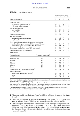
TABLE 6.4 Runoff Curve Number
Hydrologic soil group
Land use description A B C D
Cultivated land: *
without conservation treatment 72 81 88 91
with conservation treatment 62 71 78 81
Pasture or range land:
poor condition 68 79 86 89
good condition 39 61 74 80
Meadow: good condition 30 58 71 78
Wood or forest land:
thin stand, poor cover, no mulch 45 66 77 83
good cover † 25 55 70 77
Open spaces, lawns, parks, golf courses, cemeteries, etc.
good condition: grass cover on 75% or more of the area 39 61 74 80
fair condition: grass cover on 50–75% of the area 49 69 79 84
Commercial and business areas (85% impervious) 89 92 94 95
Industrial districts (75% impervious) 81 88 91 93
Residential: ‡
Average lot size Average % impervious §
1/8 acre or less 65 77 85 90 92
1/4 acre 38 61 75 83 87
1/3 acre 30 57 72 81 86
1/2 acre 25 54 70 80 85
1 acre 20 51 68 79 84
Paved parking lots, roofs, driveways, etc. ¶ 98 98 98 98
Streets and roads:
paved with curbs and storm sewers ¶ 98 98 98 98
gravel 76 85 89 91
dirt 72 82 87 89
*
For a more detailed description of agricultural land use curve numbers refer to National Engineering Handbook,
Section 4, Hydrology, Chapter 9, Aug. 1972.
†
Good cover is protected from grazing and litter and brush covered soil.
‡
Curve numbers are computed assuming the runoff from the house and driveway is directed toward the street with a
minimum of roof water directed to lawns where additional infiltration could occur.
§
The remaining pervious areas (lawn) are considered to be in good pasture condition for these curve numbers.
¶
In some warmer climates of the country a curve number of 95 may be used.
1. The actual rainfall must be found. From Fig. 6.20, for a 50-year, 24-h storm, 6 in of rain
is read.
2. The actual rainfall must be adjusted. From Table 6.5, for present CN of 75 and 6 in of
rain, an adjusted figure of 3.28 in of rain is used. This number is known as VR.
3. The actual peak discharge must be determined based on original slope of the site.
From Fig. 6.23 (for a 4 percent slope) enter with a CN of 75 and a watershed area of
300 acres. Read 125 cfs/in of rainfall. Therefore, 125 3 28 399× . = cfs peak discharge
for the undeveloped 300-acre site. (Table 6.6 should be used for intermediate slope
values, if required.)
Downloaded from Digital Engineering Library @ McGraw-Hill (www.accessengineeringlibrary.com)
Copyright © 2009 The McGraw-Hill Companies. All rights reserved.
Any use is subject to the Terms of Use as given at the website.