
Page 51 - Fundamentals of Gas Shale Reservoirs
P. 51
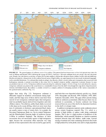
GEOGRAPHIC DISTRIBUTION OF ORGANIC MATTER‐RICH SHALES  31
                         0º    30ºE   60ºE   90ºE   120ºE  150ºE  180º   150ºW  120ºW   90ºW   60ºW   30ºW
                                                                                                 Greenland


                    Arctic Circle
                    Arctic Circle
                                                   Asia
             60ºN
                          Europe
                                                                                   North
                                                                                     America
             30ºN
                    Tropic of Cancer
                    Tropic of Cancer
                            Africa
               0º   Equator                                                                 South
                    Equator
                                                                                              America
                    Tropic of Capricorn
                    Tropic of Capricorn              Australia
              30ºS


              60ºS

                    Antarctic Circle
                    Antarctic Circle
                                       Antarctica


                        Calcareous ooze      Pelagic clay or no deposit    Glacial debris
                        Siliceous ooze       Terrigenous sediments         Shelf deposits

            FIGURE 2.5  The general pattern of sediment cover of the seafloor. This pattern has been known more or less in its present state since the
            work of Murray and Renard (1891) following the voyage of H.M.S. Challenger. The main sediment facies are pelagic clay and calcareous
            ooze. Pelagic clay, also known as red clay, is typical for the deep seafloor, whereas the calcareous facies outlines oceanic rises and platforms.
            Biosiliceous deposits, characteristic for the seafloor beneath areas of high fertility, are superimposed on the previously mentioned topograph-
            ically controlled dichotomy. The sediment that results in pelagic clay deposits, which is mostly eolian and cosmogenous dust associated with
            hydrogenous minerals, is present everywhere in the ocean, but it is masked whenever another component is present, because its mass
            accumulation rates are so low. Terrigenous sediment is present along the continental margins. In front of large rivers and submarine canyons,
            terrigenous sediment can penetrate the ocean basin to a considerable distance from the shelf. Even though this map shows sharp boundaries
            between well‐defined facies, the seafloor is actually covered by a complex pattern of overlapping mixtures of the various components of
            fine‐grained marine sediments (Fig. 2.1).

            higher than today (Fig.  2.2).  Terrigenous sediment is   mud beds that were deposited relatively quickly (e.g., Baird,
              efficiently trapped in nearshore environments during high-  1976; Macquaker and Howell, 1999; Schieber, 1994, 2003;
            stands, and thus large areas of those shelves must have been   Trabucho‐Alexandre, 2014). The gaps reflect periods during
            starved of new terrigenous sediment input; their terrigenous   which no sediment accumulated, either because there was no
            mud was probably largely derived from longshore and relict   sediment to accumulate, or because sediment was being
            offshore sources. Nevertheless, unlike black shales recovered   removed from one area of the shelf to be deposited elsewhere
            in the deep sea by ocean drilling, which are never more than   on the shelf or in deeper water.
            tens of centimeters in thickness, epicontinental black shales   In addition to terrigenous material, neritic sediments almost
            are usually meters to tens of meters thick, for example, the   always contain biogenous material (Fig.  2.1), which is a
            Devonian Chattanooga Shale (ca. 9 m in central Tennessee)     product of high fertility of surface water along continental
            and the Pliensbachian–Toarcian shales of northwest Europe     margins. This is due to a high position or breakdown of the
            (>100 m in northeast England).  The thickness of these   thermocline, which normally functions as a barrier to nutrient
              successions does not necessarily equate to high terrigenous   transport between deep and shallow, sunlit water. Upward
            input, because the successions often represent very long     mixing of nutrient‐rich water containing dissolved silica leads
            periods of time represented in the rock record by gaps and by   to high productivity in the photic zone and to a high proportion