
Page 187 - Fundamentals of Geomorphology
P. 187
170 PROCESS AND FORM
Landform elements
contour curvature. Further parameters go beyond local
From a geomorphological viewpoint, the ground sur- geometry, placing the element in a wider landscape
face is composed of landform elements. Landform setting – distance from the element to the crest, catch-
elements are recognized as simply-curved geometric sur- ment area per unit of contour length, dispersal area (the
faces lacking inflections (complicated kinks) and are land area down-slope from a short increment of contour).
considered in relation to upslope, downslope, and lat- Digitalelevationmodels (DEMs)have largely superseded
eral elements. Slope is essential in defining them. the classic work on landform elements and their descrip-
Landscape elements go by a plethora of names – facets, tors. Topographic elements of a landscape can be com-
sites, land elements, terrain components, and facies. The puted directly from a DEM and these are often classified
‘site’ (Linton 1951) was an elaboration of the ‘facet’ into primary (or first-order) and secondary (or second-
(Wooldridge 1932), and involved altitude, extent, slope, order) attributes (Moore et al. 1993). Primary attributes
curvature, ruggedness, and relation to the water table. are calculated directly from the digital elevation data and
The other terms appeared in the 1960s (see Speight the most commonly derived include slope and aspect
1974). Landform element is perhaps the best term, as (Table 7.1). Secondary attributes combine primary
it seems suitably neutral. attributes and are ‘indices that describe or characterise
Landform elements are described by local land- the spatial variability of specific processes occurring in the
surface geometry. Several parameters are derivatives of landscape’ (Moore et al. 1993, 15); examples are irradi-
altitude – slope angle, slope profile curvature, and ance and a wetness index (Table 7.1). Such methods allow
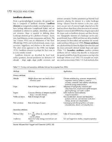
Table 7.1 Primary and secondary attributes that can be computed from DEMs
Attribute Definition Applications
Primary attributes
Altitude Height above mean sea level or local Climate variables (e.g. pressure, temperature),
reference point vegetation and soil patterns, material
volumes, cut-and-fill and visibility calculations,
potential energy determination
Slope Rate of change of elevation – gradient Steepness of topography, overland and
subsurface flow, resistance to uphill transport,
geomorphology, soil water content
Aspect Compass direction of steepest downhill Solar insolation and irradiance,
slope – azimuth of slope evapotranspiration
Profile curvature Rate of change of slope Flow acceleration, erosion and deposition
patterns and rate, soil and land evaluation
indices, terrain unit classification
Plan curvature Rate of change of aspect Converging and diverging flow, soil water
characteristics, terrain unit classification
Secondary attributes
A s
Wetness Index ln = where A s is specific catchment Index of moisture retention
tanb
and b is slope
Irradiance Amount of solar energy received per unit Soil and vegetation studies, evapotranspiration
area
Source: Adapted from Huggett and Cheesman (2002, 20)