
Page 29 - Fundamentals of Geomorphology
P. 29
12 INTRODUCING LANDFORMS AND LANDSCAPES
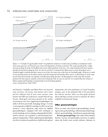
( ) Scarp retreat I () Scarp rounding I
a
c
Debris apron
20 m 20 m
() Scarp retreat II () Scarp rounding II
d
b
50 m 50 m
Figure 1.5 Example of a geomorphic model: the predicted evolution of a fault scarp according to assumptions made
about slope processes. (a) Parallel scarp retreat with deposition of debris at the base. The scarp is produced by a single
movement along the fault. (b) Parallel scarp retreat with deposition at the base. The scarp is produced by four separate
episodes of movement along the fault. In cases (a) and (b) it is assumed that debris starts to move downslope once a
threshold angle is reached and then comes to rest where the scarp slope is less than the threshold angle. Allowance is made
for the packing density of the debris and for material transported beyond the debris apron. (c) Rounding of a fault scarp
that has been produced by one episode of displacement along the fault. (d) Rounding of a fault scarp that has been
produced by four separate episodes of movement along the fault. In cases (c) and (d), it is assumed that the volume of
debris transported downslope is proportional to the local slope gradient.
Source: Adapted from Nash (1981)
and beyond. Landslides and debris flows may become temperature rises into predictions of critical boundary
more common, soil erosion may become more severe changes, such as the poleward shift of the permafrost
and the sediment load of some rivers increase, some line and the tree-line, which can then guide decisions
beaches and cliffs may erode faster, coastal lowlands may about tailoring economic activity to minimize the effects
become submerged, and frozen ground in the tundra of global environmental change.
environments may thaw. Applied geomorphologists can
address all these potentially damaging changes. Second, Other geomorphologies
aworryingaspectofglobalwarmingisitseffectonnatural
resources – water, vegetation, crops, and so on. Applied There are many other kinds of geomorphology, includ-
geomorphologists, equipped with such techniques as ing tectonic geomorphology, submarine geomorphology,
terrain mapping, remote sensing, and geographical infor- climatic geomorphology, and planetary geomorphology.
mation systems, can contribute to environmental man- Tectonic geomorphology is the study of the interplay
agement programmes. Third, applied geomorphologists between tectonic and geomorphic processes in regions
are able to translate the predictions of global and regional where the Earth’s crust actively deforms. Advances in