
Page 39 - Fundamentals of Geomorphology
P. 39
22 INTRODUCING LANDFORMS AND LANDSCAPES
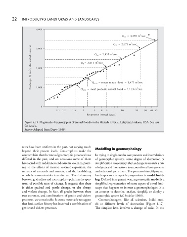
4,000
3
Q 50 = 3,398 m /sec
3
Q 25 = 2,973 m /sec
cumecs) 3,000 Q 10 = 2,435 m /sec
3
called 3
also Q 5 = 2,011 m /sec
/s, 2,000
3
(m
Q
Discharge, 1,000 Q 1.58 = most probable annual flood = 1,133 m /sec
3
Q 2.33 = mean annual flood = 1,473 m /sec
3
0
1.1 1.2 1.5 2 3 4 5 10 20 30 40 50
Recurrence interval (years)
Figure 1.11 Magnitude–frequency plot of annual floods on the Wabash River, at Lafayette, Indiana, USA. See text
for details.
Source: Adapted from Dury (1969)
rates have been uniform in the past, not varying much Modelling in geomorphology
beyond their present levels. Catastrophists make the
counterclaim that the rates of geomorphic processes have In trying to single out the components and interrelations
differed in the past, and on occasions some of them of geomorphic systems, some degree of abstraction or
have acted with suddenness and extreme violence, point- simplification is necessary: the landscape is too rich a mix
ing to the effects of massive volcanic explosions, the of objects and interactions to account for all components
impacts of asteroids and comets, and the landsliding and relationships in them.The process of simplifying real
of whole mountainsides into the sea. The dichotomy landscapes to manageable proportions is model build-
between gradualists and catastrophists polarizes the spec- ing. Defined in a general way, a geomorphic model is a
trum of possible rates of change. It suggests that there simplified representation of some aspect of a real land-
is either gradual and gentle change, or else abrupt scape that happens to interest a geomorphologist. It is
and violent change. In fact, all grades between these an attempt to describe, analyse, simplify, or display a
two extremes, and combinations of gentle and violent geomorphic system (cf. Strahler 1980).
processes, are conceivable. It seems reasonable to suggest Geomorphologists, like all scientists, build mod-
that land-surface history has involved a combination of els at different levels of abstraction (Figure 1.12).
gentle and violent processes. The simplest level involves a change of scale. In this