
Page 43 - Fundamentals of Geomorphology
P. 43
26 INTRODUCING LANDFORMS AND LANDSCAPES
F F Q Q 1km
300
300 A A Contours in feet
G G
C C Alluvium
P P B B
I I 200 E E D D Blown sand
200
J J H H O O
100
K K 100
500 River
500
River
400
400 L L
Marsh
East
M M East Marsh Taff
Taff
N N West Marsh
Marsh
est
W
Pendine
Pendine
Sands
Sands
Laugharne SandsSands
Laugharne
feet
500 I
J H
400 K G F
M L
300 29° 28°
27°
N 26° 31° 31° 30° 21°
200
32°
100
0
500
400 Q P O
300 A
23° 32° D C B 32°
200 33° E
23° 32° 32° 32°
100
0
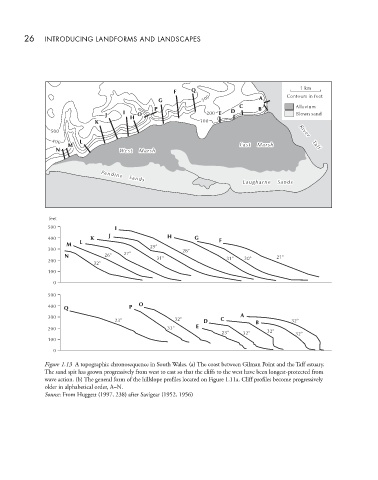
Figure 1.13 A topographic chronosequence in South Wales. (a) The coast between Gilman Point and the Taff estuary.
The sand spit has grown progressively from west to east so that the cliffs to the west have been longest-protected from
wave action. (b) The general form of the hillslope profiles located on Figure 1.11a. Cliff profiles become progressively
older in alphabetical order, A–N.
Source: From Huggett (1997, 238) after Savigear (1952, 1956)