
Page 53 - Fundamentals of Geomorphology
P. 53
36 INTRODUCING LANDFORMS AND LANDSCAPES
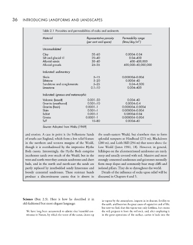
Table 2.1 Porosities and permeabilities of rocks and sediments
Material Representative porosity Permeability range
2
(per cent void space) (litres/day/m )
Unconsolidated
Clay 50–60 0.0004–0.04
Silt and glacial till 20–40 0.04–400
Alluvial sands 30–40 400–400,000
Alluvial gravels 25–35 400,000–40,000,000
Indurated: sedimentary
Shale 5–15 0.000004–0.004
Siltstone 5–20 0.0004–40
Sandstone and conglomerate 5–25 0.04–4,000
Limestone 0.1–10 0.004–400
Indurated: igneous and metamorphic
Volcanic (basalt) 0.001–50 0.004–40
Granite (weathered) 0.001–10 0.0004–0.4
Granite (fresh) 0.0001–1 0.000004–0.0004
Slate 0.001–1 0.000004–0.004
Schist 0.001–1 0.00004–0.04
Gneiss 0.0001–1 0.000004–0.004
Tuff 10–80 0.0004–40
Source: Adapted from Waltz (1969)
and erosion. A case in point is the Folkestone Sands the south-eastern Weald, but elsewhere rises to form
of south-east England, which form a low relief feature splendid ramparts at Hindhead (273 m), Blackdown
in the northern and western margins of the Weald, (280 m), and Leith Hill (294 m) that tower above the
though it is overshadowed by the impressive Hythe Low Weald (Jones 1981, 18). However, in general,
Beds cuesta. Interestingly, the Hythe Beds comprise hillslopes on the aforementioned sandstones are rarely
incoherent sands over much of the Weald, but in the steep and usually covered with soil. Massive and more
west and north-west they contain sandstones and chert strongly cemented sandstones and gritstones normally
beds, and in the north and north-east the sands are form steep slopes and commonly bear steep cliffs and
partly replaced by interbedded sandy limestones and isolated pillars. They do so throughout the world.
loosely cemented sandstones. These resistant bands Details of the influence of rocks upon relief will be
produce a discontinuous cuesta that is absent in discussed in Chapters 4 and 5.
Science (Box 2.3). Here is how he described it in in vapour by the atmosphere, imparts in its descent, fertility to
old-fashioned but most elegant language: the earth, and becomes the great cause of vegetation and of life;
but now we find, that this vapour not only fertilizes, but creates
We have long been accustomed to admire that beautiful con- the soil; prepares it from the soil rock, and, after employing it
trivance in Nature, by which the water of the ocean, drawn up in the great operations of the surface, carries it back into the