
Page 75 - Fundamentals of Physical Volcanology
P. 75
9780632054435_4_004.qxd 12/10/2007 12:19PM Page 52
52 CHAPTER 4
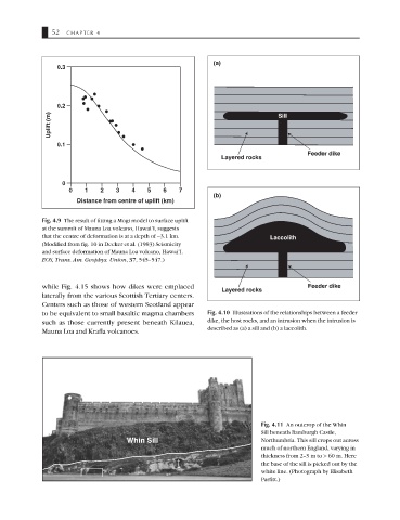
(a)
0.3
0.2
Uplift (m) Sill
0.1
Feeder dike
Layered rocks
0
0 1 2 3 4 5 6 7
(b)
Distance from centre of uplift (km)
Fig. 4.9 The result of fitting a Mogi model to surface uplift
at the summit of Mauna Loa volcano, Hawai’I, suggests
that the centre of deformation is at a depth of ∼3.1 km. Laccolith
(Modified from fig. 10 in Decker et al. (1983) Seismicity
and surface deformation of Mauna Loa volcano, Hawai’I.
EOS, Trans. Am. Geophys. Union, 37, 545–547.)
while Fig. 4.15 shows how dikes were emplaced Feeder dike
Layered rocks
laterally from the various Scottish Tertiary centers.
Centers such as those of western Scotland appear
to be equivalent to small basaltic magma chambers Fig. 4.10 Illustrations of the relationships between a feeder
such as those currently present beneath Kilauea, dike, the host rocks, and an intrusion when the intrusion is
Mauna Loa and Krafla volcanoes. described as (a) a sill and (b) a laccolith.
Fig. 4.11 An outcrop of the Whin
Sill beneath Bamburgh Castle,
Whin Sill Northumbria. This sill crops out across
much of northern England, varying in
thickness from 2–3 m to > 60 m. Here
the base of the sill is picked out by the
white line. (Photograph by Elisabeth
Parfitt.)