
Page 230 - Geochemical Remote Sensing of The Sub-Surface
P. 230
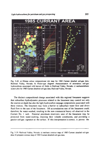
Light hydrocarbons for petroleum and gas prospecting                205


           Fig.  5-40.  a)  Ethane  colour  compositional  dot  map  for  1985 Currant  detailed  soil-gas  data,
           Railroad  Valley,  Nevada;  b)  Pixler-type  diagram  characterisation  of  anomalous  soil-gas
           hydrocarbons  associated  with  known  oil  fields  in  Railroad  Valley,  Nevada;  c)  methane/ethane
           scatter plot for  1985 Currant detailed soil-gas data, Railroad Valley, Nevada.


              The  distinct  compositional  change  associated  with  this  regional  lineament  suggests
           that  subsurface  hydrodynamic  processes  related  to  the  lineament  may  control  not  only
           the  sources  at depth  but also the  light-hydrocarbon  seepage  compositions  associated  with
           these  sources.  The  lineament  may  form  a  barrier  to  subsurface  water  flow  and  divert
           fluid  flow  to  the  east  of  the  lineament.  Oil  accumulations  east  of the  lineament  could,
           therefore,  be  water-washed,  resulting  in  the  non-commercial  heavy  oil  observed  in  the
           Currant  No.  i  well.   Potential  petroleum  reservoirs  west  of  the  lineament  may  be
           protected  from  water-washing,  retaining  their  volatile  constituents,  and  providing  a
           gassier soil-gas  signature  at  the surface.  If  this  interpretation  is correct,  it  proves  the


           Fig.  5-39.  Railroad  Valley,  Nevada:  a)  methane  contour  map  of  1985 Currant  detailed  soil-gas
           data; b) propane contour map of 1985 Currant detailed soil-gas data.