
Page 233 - Geochemical Remote Sensing of The Sub-Surface
P. 233
Light hydrocarbons for petroleum and gas prospecting 207
local significance of this regional lineament system, even though the feature is not
immediately obvious from small-scale remote-sensing data alone. It is also important to
note that the regional geochemical study conducted in 1984 would not have been
sufficient to support this interpretation, and that close detailed data gathered in 1985
were required to properly confirm the relationships between lineaments and hydrocarbon
seepage in this case.
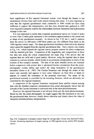
It is very important to realise that a regional geochemical survey on 1.6-km (1-mile)
or even 5-km (3-mile) grids represents a low-resolution approximation to the actual size
or shape of any geochemical anomaly. As shown in Fig. 5-39, the C1 and C3 patterns
from the survey on 300-metre (1000-feet) centres are very different from those in the
1984 regional contour maps. The sharp geochemical boundaries observed in the detailed
study cannot be mapped from the regional geochemical data. This is shown very clearly
in Fig. 5-41, which expands the regional survey propane contour for direct comparison
with the detailed grid data. Comparison of the magnitudes and compositions in these
two data sets using the colour compositional dot maps (Fig. 5-42) proves that the
regional data are valid and of good quality. However, using the regional data to draw
contours is a serious mistake, which results in an erroneous interpretation in terms of the
location of this complex anomaly. The data of the more detailed survey are essential
before comparison with seismic data is attempted.Fracture orientations from the aerial-
photography overlay define and control the sharp boundaries of the geochemical
anomalies (Jones et al., 1985). The Currant lineament cuts through the centre of this
major seep anomaly and appears to have some influence on fluid flow at depth (it
appears to control the economics of the potential reservoirs). The shape of the
geochemical anomaly is controlled by the bounding fractures, which are obviously not
controlled by this regional lineament.
A comparison of the regional lineament interpreted from satellite remote-sensing
data with the detailed composite interpretation from aerial photography shows that the
azimuth of the Currant lineament is expressed only in the short photolineaments.
However, the regional lineament is not obvious from only the short photolineaments.
Based on only the aerial photography we might suggest that this lineament is not real;
the geochemical data, however, clearly shows otherwise and clearly shows the value of
integrated multidisciplinary interpretations.
Fig. 5-41. Comparison of propane contour maps for soil-gas data, Currant area, Railroad Valley,
Nevada, illustrating importance of sample spacing: a) 1984 regional survey; and b) 1985 detailed
survey.