
Page 67 - Geochemical Remote Sensing of The Sub-Surface
P. 67
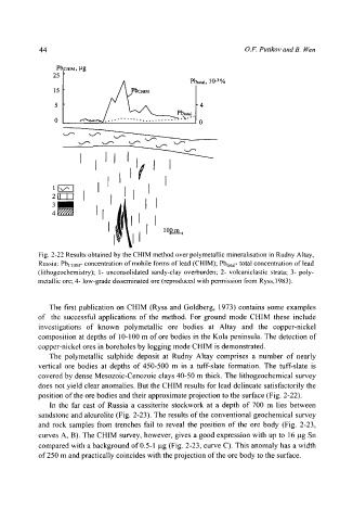
44                                                    O.F. Putikov and B.  Wen


                PI: cI-nM, gg
               25
                                                   Pbtotai, 10 -3 %


                            /      ~    ~      Pbto~.
                      "  "                      "\'"   0


                      I  I           I   I  I

               ll l        II               I
               ,lltl   I      I     I


                             I         I     0pm,
                               I

           Fig.  2-22  Results  obtained  by the CHIM  method  over polymetallic  mineralisation  in  Rudny  Altay,
           Russia:  Pbcl~lM- concentration  of mobile  forms  of lead  (CHIM);  Pbtotal- total  concentration  of lead
           (lithogeochemistry);  1-  unconsolidated  sandy-clay  overburden;  2-  volcaniclastic  strata;  3-  poly-
           metallic  ore; 4-  low-grade  disseminated  ore (reproduced  with  permission  from  Ryss, 1983).


              The  first  publication  on  CHIM  (Ryss  and  Goldberg,  1973)  contains  some  examples
           of  the  successful  applications  of  the  method.  For  ground  mode  CHIM  these  include
           investigations  of  known  polymetallic  ore  bodies  at  Altay  and  the  copper-nickel
           composition at depths of  10-100 m of ore bodies  in the  Kola peninsula.  The  detection  of
           copper-nickel ores in boreholes by logging mode CHIM  is demonstrated.
              The  polymetallic  sulphide  deposit  at  Rudny  Altay  comprises  a  number  of  nearly
           vertical  ore  bodies  at  depths  of 450-500  m  in  a  tuff-slate  formation.  The  tuff-slate  is
           covered by dense  Mesozoic-Cenozoic clays 40-50 m thick.  The  lithogeochemical  survey
           does not yield clear anomalies.  But the CHIM  results  for lead delineate  satisfactorily the
           position of the ore bodies and their approximate projection to the surface (Fig. 2-22).
              In  the  far  east  of Russia  a  cassiterite  stockwork  at  a  depth  of  700  m  lies  between
           sandstone and aleurolite  (Fig.  2-23).  The results of the conventional  geochemical  survey
           and  rock  samples  from  trenches  fail  to  reveal  the  position  of the  ore  body  (Fig.  2-23,
           curves A,  B). The CHIM  survey, however,  gives a good expression  with  up to  16 lag Sn
           compared with a background of 0.5-1  lag (Fig. 2-23,  curve C).  This anomaly has a width
           of 250 m and practically coincides with the projection of the ore body to the surface.