
Page 158 - Geology of Carbonate Reservoirs
P. 158
DIAGNOSIS AND MAPPING OF DEPOSITIONAL RESERVOIRS 139
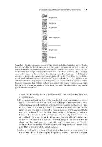
Rhythmites
Laminites
Rhythmites
Fine Turbidites
Rhythmites
Laminites
Figure 5.14 Basinal successions consist of fine (distal) turbidites, laminites, and rhythmites
that are probably the default successions in the basinal environment on both ramps and
shelves. Laminites are millimeter - scale, dark colored, sparsely fossiliferous, usually organic -
rich beds that may occupy stratigraphic sections tens to hundreds of meters thick. They rep-
resent sedimentation in the cold, dark, dysoxic, deep water. Rhythmites are much like distal
turbidites in that they fine - upward and may exhibit small ripples. They differ from turbidites
by their small (millimeter - to - centimeter) scale. Typical rhythmites are rarely more than a few
centimeters thick but they may be repeated cyclically over many meters in aggregate vertical
thickness. The coarse – fine rhythms probably represent events: storms or small seismic events
that stir shallow - water sediments to form density currents. Distal turbidites may exhibit
typical “ Bouma sequences. ”
dissolution diagenesis that may be interpreted from wireline log signatures
or seismic clues.
2. From previous identification of the standard depositional succession repre-
sented in the reservoir, predict the 3D size and shape of the depositional body.
Anticipate cyclical sedimentation and incomplete successions. Reservoir thick-
ness depends on how many episodes (cycles) of sedimentation compose the
reservoir and how many erosional or nondepositional events decreased total
reservoir thickness. Expect variations in depositional thickness over long dis-
tances and variations in thickness from updip to downdip limits of the depo-
sitional body. For example, barrier island successions are thick if both beaches
and dunes are present and “ stacked ” together; they are thin where dunes are
absent and the beach was penetrated at its updip or downdip edge. Debrites
and turbidites are thicker near the source and updip center of the sediment
pile. They are thinner at the distal margins.
3. After several wells have been drilled, use the data to map average porosity in
the reservoir interval and compare the porosity map with a structure map on