
Page 154 - Geology of Carbonate Reservoirs
P. 154
PALEOTOPOGRAPHY AND DEPOSITIONAL FACIES 135
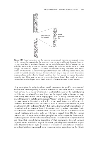
Storm
May/may not washover
be present
fan
Figure 5.10 Ideal succession for the lagoonal environment. Lagoons are ponded behind
barrier islands that characterize the nearshore zone on ramps, although they could exist on
open shelves. Barrier islands and lagoons are not typical of rimmed shelves because rims act
as baffles to incoming waves and currents causing the back - reef interior to be a “ lower
energy ” environment. Lagoonal successions are characterized by mudstones and wacke-
stones, low taxonomic diversity with specialized (euryhaline and eurythermic) biota, and
usually by vertical, infaunal burrows. Storm washovers may or may not occur. They are so
common along modern barrier island coastlines that they should be present in ancient
examples also. They may not always be recognized even though they consist of coarser,
unsorted material and open ocean fossils washed in from the seaward side of barriers.
lying assumption in assigning these model successions to specifi c environmental
zones is that the bathymetry across the platform has low relief. That is, the seabed
must have no more than a few meters of local relief in order for the hydrodynamic
conditions to remain uniform, and hence for the deposit to be uniform over large
areas along depositional strike. Topographic relief is rarely uniform and fl at. If
seabed topography includes prominences ( “ highs ” ) and depressions ( “ lows ” ), then
the patterns of sedimentation will reflect these local features as differences in
thickness, differences in facies character, or both. In siliciclastic sedimentation, lows
are always filled by sediment “ thicks ” that outline the lows. Bathymetric highs, on
the other hand, are zones of limited deposition, nondeposition, or erosion. In the
case of detrital carbonate sedimentation, the same rule applies. Filled lows become
isopach thicks and antecedent highs are reflected as isopach thins. This fact enables
us to use interval isopach maps to interpret platform paleotopography . For example,
thickness patterns on interval isopach maps reveal the outlines of bathymetric lows
and highs that existed during deposition of that stratigraphic interval. Ancient
depressions are revealed as isopach thicks and paleo - highs are revealed as isopach
thins. Presedimentation highs are zones of low sediment accumulation or erosion,
assuming that there was enough wave or current action sweeping over the high to