
Page 182 - Geothermal Energy Systems Exploration, Development, and Utilization
P. 182
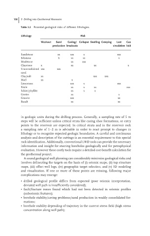
158  3 Drilling into Geothermal Reservoirs
                               Table 3.2 Potential geological risks of different lithologies.


                               Lithology                          Risk
                                           Washout  Sand  Caving/ Collapse Swelling Creeping  Lost  Gas
                                                 production breakouts               circulation kick

                               Sandstone            xx      xxx    x                   xxx
                               Siltstone            X       xx     xx                  x
                               Mudstone                     xx    xxx
                               Claystone   x                xx           xx                  x
                               Unconsolidated xxx   xxx
                               sand
                               Clay/salt   xx                            xxx   xxx
                               Marl        xx               x
                               Limestone                    xxx    x                   xxx
                               Shale                        xx     x     xx                 xxx
                               Schist/phyllite              xx     x      x
                               Gneiss                       xx                         x
                               Granite                      xxx                        xx
                               Basalt                       xx                         xx


                               in geologic units during the drilling process. Generally, a sampling rate of 5 m
                               steps will be sufficient unless critical strata like casing shoe formations, or entry
                               points to the reservoir are expected. In critical strata and in the reservoir rock
                               a sampling rate of 1–2 m is advisable in order to react prompt to changes in
                               lithology or to recognize expected geologic boundaries. A careful and continuous
                               analysis and description of the cuttings is an essential requirement to this special
                               rock identification. Additionally, conventional LWD tools can provide the necessary
                               information and insight for steering boreholes geologically and for petrophysical
                               evaluation. However these costly tools require a detailed cost-benefit calculation for
                               the geothermal project.
                                 A sound geological well planning can considerably minimize geological risks and
                               involves delineating the targets on the basis of (i) seismic maps, (ii) top structure
                               maps, (iii) offset well logs, (iv) geographic target selection, and (v) 3D modeling
                               and visualization. If one or more of these points are missing, following major
                               complications may emerge:
                               • drilled geological profile differs from expected (poor seismic interpretation,
                                 deviated well path is insufficiently considered);
                               • fault/fracture zones found which had not been detected in seismic profiles
                                 (subseismic features);
                               • borehole stability/caving problems/sand production in weakly consolidated for-
                                 mations;
                               • borehole stability depending of trajectory in the current stress field (high stress
                                 concentration along well path);