
Page 184 - Global Tectonics
P. 184
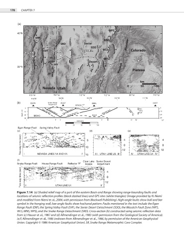
170   CHAPTER 7


           (a)


           40°N


           39°N


                   115°W           114°W            113°W           112°W           111°W
           (b)     EGAN      Snake Range  FOOT        SMEL                                CAST
                             Detachment      reflector "F"
                0                   SRF                                           Joes        0
              Depth, km  10  MOHO  Egan Range f.   House    Range f.   MOHO  Wasatch fault   Gunnison f.   Valley  10
                                        Sevier Desert d.
                                                                                  Fault
                                                                                              20
                             Spring Valley f.
               20
               30                                                                             30
                 I               I'  II                     II'  III         III'  IV          IV'
                                              kilometers
                                       0   25   50   75  100
           Egan Range Fault  Spring Valley Fault
           (c)                                       (d)                   (e)
             Two-way time (sec)                    10 5                 12                     12 4 8
                                                                         4
                                                                         8


           (f)  I      NEVADA LINES N4 AND 5N    I   15  III  UTAH LINE U3  III   IV  UTAH LINE U4  IV
                                                 Clear Lake Sevier Desert
           Snake Range Fault  House Range Fault  Reflector “F”  Scarps  Detachment
             Two-way time (sec)                               12 4 8


                                 UTAH LINE U1
                II
                                                            II
           Figure 7.14  (a) Shaded relief map of a part of the eastern Basin and Range showing range-bounding faults and


           locations of seismic reflection profiles (black dashed lines) and GPS sites (white triangles) (image provided by N. Niemi

           and modified from Niemi et al., 2004, with permission from Blackwell Publishing). High-angle faults show ball and bar
           symbol in the hanging wall, low-angle faults show hachured pattern. Faults mentioned in the text include the Egan
           Range Fault (ERF), the Spring Valley Fault (SVF), the Sevier Desert Detachment (SDD), the Wasatch Fault Zone (WFS,

           WLS, WNS, WPS), and the Snake Range Detachment (SRD). Cross-section (b) constructed using seismic reflection data
           from (c) Hauser et al., 1987 and (d) Allmendinger et al., 1983 (with permission from the Geological Society of America).
           (e,f) Allmendinger et al., 1986 (redrawn from Allmendinger et al., 1986, by permission of the American Geophysical
           Union. Copyright © 1986 American Geophysical Union). SR, Snake Range Metamorphic Core Complex.