
Page 181 - Global Tectonics
P. 181
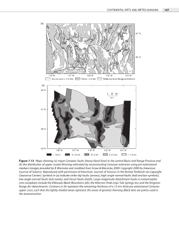
CONTINENTAL RIFTS AND RIFTED MARGINS  167


                         (a)

                                                                  SHEEP RANGE BLOCK BLOCK  mp  ts ts  37  N
                                                                  SHEEP RANGE
                                                                      mp


                               SIERRA NEVADA SIERRA NEVADA  kr kr  SPRING MOUNTAINS BLOCK  COLORADO PLATEAU COLORADO PLATEAU  36  N


                                                                     eb
                                                        SPRING MOUNTAINS BLOCK
                                         MOJAVE DESERT               eb
                                         MOJAVE DESERT
                                            BLOCK
                                            BLOCK
                              118  W     117  W      116  W     115  W      114  W
                                Alluvial cover ( 2.5 Ma)  Rocks  2.5 Ma  Relatively minor Neogene tectonism
                          (b)
                         38  N
                                                                 0  25  50
                                                                   km


                         37  N


                         36  N


                         35  N
                                   118  W   117  W    116  W   115  W    114  W
                                   15 km    15–10 km   10–5 km    5–2.5 km      2.5 km
            Figure 7.13  Maps showing (a) major Cenozoic faults (heavy black lines) in the central Basin and Range Province and
            (b) the distribution of upper crustal thinning estimated by reconstructing Cenozoic extension using pre-extensional

            markers (images provided by B. Wernicke and modified from Snow & Wernicke, 2000. Copyright 2000 by American
            Journal of Science. Reproduced with permission of American Journal of Science in the format Textbook via Copyright
            Clearance Center). Symbols in (a) indicate strike-slip faults (arrows), high-angle normal faults (ball and bar symbols),
            low-angle normal faults (tick marks), and thrust faults (teeth). Large-magnitude detachment faults in metamorphic
            core complexes include the Eldorado-Black Mountains (eb), the Mormon Peak (mp), Tule Springs (ts), and the Kingston
            Range (kr) detachments. Contours in (b) represent the remaining thickness of a 15-km-thick pre-extensional Cenozoic
            upper crust, such that the lightly shaded areas represent the areas of greatest thinning. Black dots are points used in
            the reconstruction.