
Page 178 - Global Tectonics
P. 178
164 CHAPTER 7
CO
40 N
Scale:
10 mm a 1
38 N
0 500
UT
km
36 N SAF NV
AZ
CA
122 W 120 W 118 W 116 W 114 W 112 W 110 W
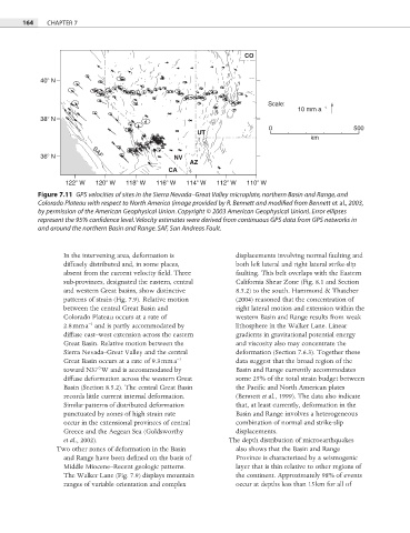
Figure 7.11 GPS velocities of sites in the Sierra Nevada–Great Valley microplate, northern Basin and Range, and
Colorado Plateau with respect to North America (image provided by R. Bennett and modified from Bennett et al., 2003,
by permission of the American Geophysical Union. Copyright © 2003 American Geophysical Union). Error ellipses
represent the 95% confidence level. Velocity estimates were derived from continuous GPS data from GPS networks in
and around the northern Basin and Range. SAF, San Andreas Fault.
In the intervening area, deformation is displacements involving normal faulting and
diffusely distributed and, in some places, both left lateral and right lateral strike-slip
absent from the current velocity fi eld. Three faulting. This belt overlaps with the Eastern
sub-provinces, designated the eastern, central California Shear Zone (Fig. 8.1 and Section
and western Great basins, show distinctive 8.5.2) to the south. Hammond & Thatcher
patterns of strain (Fig. 7.9). Relative motion (2004) reasoned that the concentration of
between the central Great Basin and right lateral motion and extension within the
Colorado Plateau occurs at a rate of western Basin and Range results from weak
−1
2.8 mm a and is partly accommodated by lithosphere in the Walker Lane. Linear
diffuse east–west extension across the eastern gradients in gravitational potential energy
Great Basin. Relative motion between the and viscosity also may concentrate the
Sierra Nevada–Great Valley and the central deformation (Section 7.6.3). Together these
−1
Great Basin occurs at a rate of 9.3 mm a data suggest that the broad region of the
toward N37°W and is accommodated by Basin and Range currently accommodates
diffuse deformation across the western Great some 25% of the total strain budget between
Basin (Section 8.5.2). The central Great Basin the Pacific and North American plates
records little current internal deformation. (Bennett et al., 1999). The data also indicate
Similar patterns of distributed deformation that, at least currently, deformation in the
punctuated by zones of high strain rate Basin and Range involves a heterogeneous
occur in the extensional provinces of central combination of normal and strike-slip
Greece and the Aegean Sea (Goldsworthy displacements.
et al., 2002). The depth distribution of microearthquakes
Two other zones of deformation in the Basin also shows that the Basin and Range
and Range have been defined on the basis of Province is characterized by a seismogenic
Middle Miocene–Recent geologic patterns. layer that is thin relative to other regions of
The Walker Lane (Fig. 7.9) displays mountain the continent. Approximately 98% of events
ranges of variable orientation and complex occur at depths less than 15 km for all of