
Page 177 - Global Tectonics
P. 177
CONTINENTAL RIFTS AND RIFTED MARGINS 163
Oregon Idaho
California Nevada Utah
Western
Sierra-Great Great
40 Valley Basin Central 40 N Walker Lane
Great Eastern
Basin Great
Basin
Intermountain seismic belt
2.8 mm
11.4 mm a 1
a 1 Eastern California shear zone
Eastern California/central Nevada
Arizona
seismic belt
35 35
San Andreas Fault
Colorado
50 mm Plateau 0 500
a 1 km
Pacific 0 mm a 1
Plate
MEXICO
120 115 W
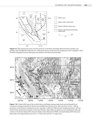
Figure 7.9 Map showing the various tectonic provinces of the Basin and Range determined from geodetic and
geologic data (modified from Bennett et al., 2003, by permission of the American Geophysical Union. Copyright © 2003
American Geophysical Union). Rates given are relative to the North American plate.
40 N
38 N
36 N
122 W 120 W 118 W 116 W 114 W 112 W 110 W
Figure 7.10 Shaded relief map of the northern Basin and Range showing major faults and earthquake focal
mechanisms (image provided by R. Bennett and modified from Bennett et al., 2003, and Shen-Tu et al., 1998, by
permission of the American Geophysical Union. Copyright © 2003 and 1998 American Geophysical Union). SAF, San
Andreas Fault. Northward translation of the Sierra Nevada–Great Valley microplate is accommodated by strike-slip
motion on the Owens Valley (OVF), Panamint Valley–Hunter Mountain (PVHM), and Death Valley (DVF) fault zones.
Black boxes show approximate area of Fig. 7.13 (lower box) and Fig. 7.14 (upper box).