
Page 176 - Global Tectonics
P. 176
162 CHAPTER 7
7.3 GENERAL exceed those observed in narrow continental rifts
(Section 7.2).
The Basin and Range example thus shows that con-
CHARACTERISTICS OF tinental lithosphere may be highly extended without
rupturing to form a new ocean basin. This pattern is
WIDE RIFTS characteristic of rifts that form in relatively thin, hot,
and weak continental lithosphere. Here, the key fea-
tures that distinguish wide rifts from their narrow rift
One of the most commonly cited examples of a wide counterparts are illustrated using the Basin and Range
intracontinental rift is the Basin and Range Province of and the Aegean Sea provinces as examples:
western North America (Fig. 7.1). In this region, large
extensional strains have accumulated across a zone 1 Broadly distributed deformation. The Basin and
ranging in width from 500 to 800 km (Fig. 7.8). In the Range Province is bounded on the west by the
central part of the province, some 250–300 km of hori- greater San Andreas Fault system and Sierra
zontal extension measured at the surface has occurred Nevada–Great Valley microplate and on the east
since ∼16 Ma (Snow & Wernicke, 2000). In eastern by the Colorado Plateau (Figs 7.8, 7.9). Both
Nevada and western Utah alone the amount of total the Sierra and the Plateau record comparatively
−2
horizontal surface extension is approximately 120– low heat fl ow values (40–60 mW m ) and
150 km (Wernicke, 1992). These values, and the width virtually no Cenozoic extensional deformation
of the zone over which the deformation occurs, greatly (Sass et al., 1994; Bennett et al., 2003). In
between these two rigid blocks Cenozoic
deformation has resulted in a broad zone of
linear, north-trending mountain ranges of
125 W 120 W 115 W 110 W 105 W approximately uniform size and spacing across
thousands of square kilometers. The mountain
ranges are about 15–20 km wide, spaced
approximately 30 km apart, and are elevated
∼1.5 km above the adjacent sedimentary
45 N
45 basins. Most are delimited on one side by a
Columbia major range-bounding normal fault. Some
Columbia
Plateau strike-slip faulting also is present. In the
Plateau
northern part of the province (latitude 40°N)
40 N
40 roughly 20–25 basin-range pairs occur across
Colorado
Colorado 750 km.
Plateau
Plateau
The present day deformation field of the Basin
and Range is revealed by patterns of
35 N seismicity (Figs 7.8, 7.10) and horizontal
35
Sierra Nevada
Sierra Nevada
Mojave
Mojave velocity estimates (Fig. 7.11) derived
Desert
Desert
0 400 km from continuous GPS data (Section 5.8)
125 120 115 110 105 (Bennett et al., 2003). The data show two
prominent bands of high strain rate along
the eastern side of the Sierra Nevada and the
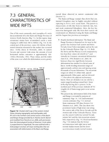
Figure 7.8 Shaded relief map of the western United
western side of the Colorado Plateau. These
States showing topography and earthquakes with
M ≥ 4.8 in the northern and central sectors of the Basin are the eastern California/central Nevada
and Range (image provided by A. Pancha and A. Barron seismic belt and the Intermountain seismic
and modified from Pancha et al., 2006, with permission belt, respectively (Fig. 7.9). Focal mechanisms
from the Seismological Society of America). Circle radius (Fig. 7.10) indicate that the former
is proportional to magnitude. The area outlined with a accommodates both right lateral and
bold polygon encloses all major earthquakes that are normal displacements and the latter
associated with deformation of the Basin and Range. accommodates mostly normal motion.