
Page 211 - Global Tectonics
P. 211
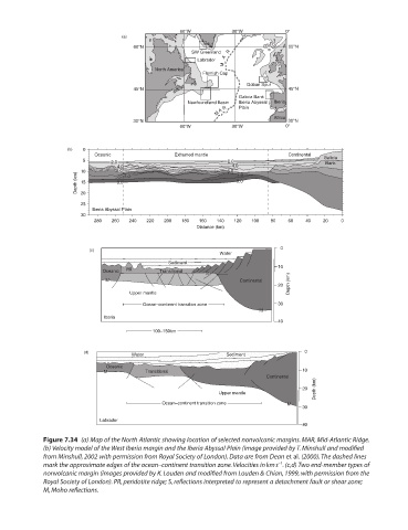
60°W          30°W          0°
                                 (a)
                                    60°N                                     60°N
                                                   SW Greenland M   A   R
                                                     Labrador
                                          North America
                                                      Flemish Cap
                                                                  Goban Spur
                                    45°N                                     45°N
                                                                Galicia Bank
                                                  Newfoundland Basin  Iberia Abyssal   Iberia
                                                          M A R  Plain
                                    30°N                                 Africa  30°N
                                                60°W          30°W          0°


                   (b)   0
                          Oceanic              Exhumed mantle                Continental
                       5      2.0                            2.0                      Galicia
                                                                                      Bank
                                4.0                           4.0
                      10        6.0  7.0                     6.0  7.0
                     Depth (km)  15  8.0                       8.0
                      20
                      25
                         Iberia Abyssal Plain
                      30
                          280  260  240  220  200  180  160  140  120  100  80  60  40  20  0
                                                     Distance (km)

                                                                           0
                        (c)
                                                           Water
                                             Sediment
                                                                          10
                            Oceanic  PR    Transitional  S
                             M                                  Continental
                                                                          20  Depth (km)
                                   Upper mantle
                                       Ocean–continent transition zone    30
                                                                     M
                            Iberia
                                                                          40
                                         100–150km


                       (d)          Water                   Sediment             0
                             Oceanic
                            M          Transitional                             10
                                                                       Continental
                                                                                    Depth (km)
                                                                                20
                                                          Upper mantle
                                            Ocean–continent transition zone  M
                                                                                30
                           Labrador
                                                                                40
            Figure 7.34  (a) Map of the North Atlantic showing location of selected nonvolcanic margins. MAR, Mid-Atlantic Ridge.

            (b) Velocity model of the West Iberia margin and the Iberia Abyssal Plain (image provided by T. Minshull and modified
            from Minshull, 2002 with permission from Royal Society of London). Data are from Dean et al. (2000). The dashed lines
                                                                          −1
            mark the approximate edges of the ocean–continent transition zone. Velocities in km s . (c,d) Two end-member types of
            nonvolcanic margin (images provided by K. Louden and modified from Louden & Chian, 1999, with permission from the


            Royal Society of London). PR, peridotite ridge; S, reflections interpreted to represent a detachment fault or shear zone;

            M, Moho reflections.