
Page 208 - Global Tectonics
P. 208
194 CHAPTER 7
(a) 22
(b) 23 WBM
SVALBARD 70 ˚ N -3000 12 14 24A 22 -1000
Barents Sea Lofoten Basin 24B 20 26 30
16
11 24A 24 28
WBM 12 23
A 14 18
22 24A 34
LVM 24B
69 ˚ N 23 14 14 30 38
NORWAY 24A 18 -2000 14 22 36
VM -3000 16 20
24B 16 24 22
22 20 18 40
68 ˚ N 24 32
22
30 38
24 26 22 34
22 20
20 VM -1000 shelf edge 24 26 50 km
22
lava 28
boundary 20
67 ˚ N 18
5 ˚E 10 ˚E A' 15 ˚E
Shelf edge 23 Sea floor Transfer zone Continent - ocean Local minimum
spreading anomaly boundary
Flood basalt Crustal transect Fracture zone Local maximum Moho gradient
boundary
(c) 22 23 -1000
70 ˚N 300 24A
Lofoten Basin 24B
0 22 24A
A 1 1 No data
2 24 A 24B
69˚N 23 3
3
3 2
4 24A 1
5 -2000
-1000
24B 6 0 Shelf edge
68˚N
Lava
7 8 9 boundary
3
2 4 1 2 50 km
3 5 0
6 5 4 > 5 km
67˚N
5 ˚E 10 ˚E A' 15 ˚E
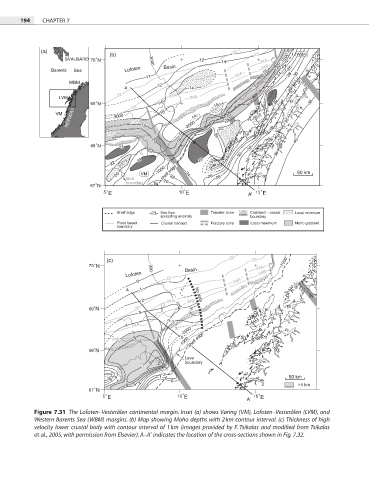
Figure 7.31 The Lofoten–Vesterålen continental margin. Inset (a) shows Vøring (VM), Lofoten–Vesterålen (LVM), and
Western Barents Sea (WBM) margins. (b) Map showing Moho depths with 2 km contour interval. (c) Thickness of high
velocity lower crustal body with contour interval of 1 km (images provided by F. Tsikalas and modified from Tsikalas
et al., 2005, with permission from Elsevier). A–A′ indicates the location of the cross-sections shown in Fig. 7.32.