
Page 262 - Global Tectonics
P. 262
240° 242° 244°
(a)
San
Joaquin
Parkfield Valley
36° β 36°
Local SAF strike
n 70
β 68 7
Garlock Fault
Mojave Desert
“Big Bend” San Andreas Fault
34° 34°
LA
150 km USA
Mexico
240° 242° 244°
Surface Trace of
(b)
San Andreas Fault
Middle Mountain
0
SAFOD 4 ? 8 6
SAFOD
20
6 4
1 8 2 San Andreas Fault Zone San Andreas Fault Zone 8
Depth (km) 2 10
Pilot
Hole 30
50
75
3 250 100
VE 1:1
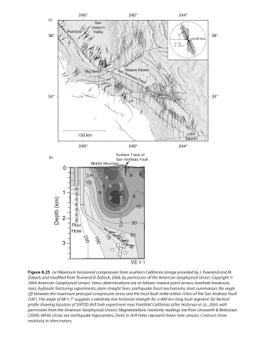
Figure 8.25 (a) Maximum horizontal compression from southern California (image provided by J. Townend and M.
Zoback and modified from Townend & Zoback, 2004, by permission of the American Geophysical Union. Copyright ©
2004 American Geophysical Union). Stress determinations are as follows: inward-point arrows, borehole breakouts;
stars, hydraulic fracturing experiments; plain straight lines, earthquake focal mechanisms. Inset summarizes the angle
(b) between the maximum principal compressive stress and the local fault strike within 10 km of the San Andreas Fault
(SAF). The angle of 68 ± 7° suggests a relatively low frictional strength for a 400-km-long fault segment. (b) Vertical
profile showing location of SAFOD drill hole experiment near Parkfield California (after Hickman et al., 2004, with
permission from the American Geophysical Union). Magnetotelluric resistivity readings are from Unsworth & Bedrosian
(2004). White circles are earthquake hypocenters. Ovals in drill holes represent down-hole sensors. Contours show
resistivity in ohm-meters.