
Page 265 - Global Tectonics
P. 265
250 CHAPTER 9
9.1 OCEAN ocean floor so that its base is 7–8 km below sea level.
The trenches in the western Pacific are typically deeper
TRENCHES than those of the eastern Pacific margin, the greatest
trench depths, of 10–11 km, occurring in the Mariana
and Tonga–Kermadec trenches. The main control on
the maximum depth of a particular trench would appear
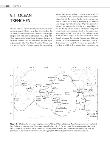
Oceanic trenches are the direct manifestation of under- to be the age of the oceanic lithosphere being sub-
thrusting oceanic lithosphere, and are developed on the ducted, as this determines the depth to the oceanic crust
oceanward side of both the island arcs and Andean-type entering the trench (Section 6.4). The striking contrast
orogens that form above subduction zones (Fig. 9.1). between trench depths in the east and west Pacifi c is
They represent the largest linear depressed features of largely explained therefore by the systematic difference
the Earth’s surface, and are remarkable for their depth in the age of the ocean floor in these areas (Plate 4.1
and continuity. The Peru–Chile Trench is 4500 km long between pp. 244 and 245). Trenches are generally 50–
and reaches depths of 2–4 km below the surrounding 100 km in width and in section form an asymmetric
0 60 E 120 E 180 120 W 60 W
60 Alaska
Kamchatka
Alps Kurile Aleutians Cascadia
Aegean NE Japan Atlantic
Himalaya Nankai Ocean
30 Ryukyu Izu-
Makran Mariana México Lesser
Luzon
Guatemala Antilles
Burma Mindanao Pacific Costa Rica
0 New Britain Ocean
Sumatra Ecuador/Colombia
Atlantic Indian Java New Peru
Ocean Ocean Hebrides Tonga Andes
Lau Basin
30 Kermadec N. Chile
Hikurangi
(New Zealand) S. Chile
Macquarie
60
South
Sandwich
Figure 9.1 The location of convergent plate margins (thin solid lines with barbs). Accretionary margins are indicated
by solid barbs, and erosive margins by open barbs (Sections 9.6, 9.7). The thick solid lines are active spreading centers
and include those in backarc basins (Section 9.10) (modified from Stern, 2002, and from Clift & Vanucchi, 2004, by
permission of the American Geophysical Union. Copyright © 2002 and 2004 American Geophysical Union).