
Page 257 - Global Tectonics
P. 257
CONTINENTAL TRANSFORMS AND STRIKE-SLIP FAULTS 243
pressures characterize the Alpine Fault and other high rates of erosion unloads the lithosphere and causes
major strike-slip fault zones. the upward advection of heat as deep crustal rocks are
Laboratory experiments on the mechanics of fault- exhumed (Koons, 1987; Batt & Braun, 1999; Willett,
ing show that high fl uid pressures in the crust result in 1999). If the exhumation is faster than the rate at which
a reduction in the magnitude of differential stress the advected heat diffuses into the surrounding region,
required to slip on a fault (Section 2.10.2). In New then the temperature of the shallow crust rises (Beau-
Zealand, this reduction in the crustal strength is implied mont et al., 1996). This thermal disturbance weakens
by an unusually thin (8 km) seismogenic layer, which the lithosphere because of the high sensitivity of rock
coincides with the top of the low velocity zone beneath strength to temperature (Section 2.10).
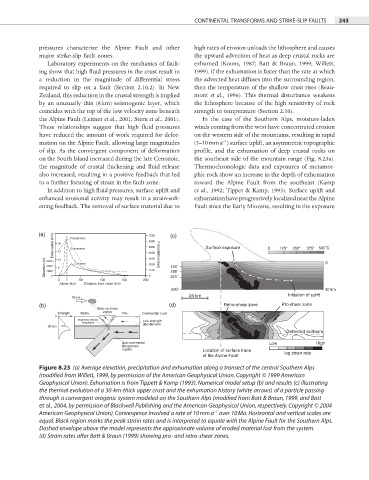
the Alpine Fault (Leitner et al., 2001; Stern et al., 2001). In the case of the Southern Alps, moisture-laden
These relationships suggest that high fl uid pressures winds coming from the west have concentrated erosion
have reduced the amount of work required for defor- on the western side of the mountains, resulting in rapid
−1
mation on the Alpine Fault, allowing large magnitudes (5–10 mm a ) surface uplift, an asymmetric topographic
of slip. As the convergent component of deformation profile, and the exhumation of deep crustal rocks on
on the South Island increased during the late Cenozoic, the southeast side of the mountain range (Fig. 8.23a).
the magnitude of crustal thickening and fl uid release Thermochronologic data and exposures of metamor-
also increased, resulting in a positive feedback that led phic rock show an increase in the depth of exhumation
to a further focusing of strain in the fault zone. toward the Alpine Fault from the southeast (Kamp
In addition to high fluid pressures, surface uplift and et al., 1992; Tippet & Kamp, 1993). Surface uplift and
enhanced erosional activity may result in a strain-soft- exhumation have progressively localized near the Alpine
ening feedback. The removal of surface material due to Fault since the Early Miocene, resulting in the exposure
(a) Precipitation 7000 (c)
Exhumation (km) 20 Exhumation 5000 Surface exposure 0 125° 250° 375° 500˚C
15
4000
Elevation (m) 3000 10 Elevation 3000 125˚ 0
2000
2000
5
1000
6000 Precipitation (mm)
250˚
1000
0
0 50 100 150 200 0 375˚
Alpine fault Distance from coast (km)
500˚ 30 km
25 km Initiation of uplift
Wind
(b) (d) Retro-shear zone Pro-shear zone
Step-up shear
Strength Retro- zones Pro- Continental crust
0
Imposed velocity Low strength
singularity
30 km décollement
S
Deflected isotherm
Sub-continental Low High
lithospheric
mantle Location of surface trace
of the Alpine Fault log strain rate
Figure 8.23 (a) Average elevation, precipitation and exhumation along a transect of the central Southern Alps
(modified from Willett, 1999, by permission of the American Geophysical Union. Copyright © 1999 American
Geophysical Union). Exhumation is from Tippett & Kamp (1993). Numerical model setup (b) and results (c) illustrating
the thermal evolution of a 30-km-thick upper crust and the exhumation history (white arrows) of a particle passing
through a convergent orogenic system modeled on the Southern Alps (modified from Batt & Braun, 1999, and Batt
et al., 2004, by permission of Blackwell Publishing and the American Geophysical Union, respectively. Copyright © 2004
−1
American Geophysical Union). Convergence involved a rate of 10 mm a over 10 Ma. Horizontal and vertical scales are
equal. Black region marks the peak strain rates and is interpreted to equate with the Alpine Fault for the Southern Alps.
Dashed envelope above the model represents the approximate volume of eroded material lost from the system.
(d) Strain rates after Batt & Braun (1999) showing pro- and retro-shear zones.