
Page 299 - Global Tectonics
P. 299
284 CHAPTER 9
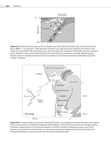
Outlined region of
partial melting
(a) 0
Lithosphere
Solidus
Pacific slab
Depth (km) Fertile mantle
Depleted mantle
500
Figure 9.33 Model for the formation of the Lau backarc basin (after Martínez & Taylor, 2002, with permission from
Nature 416, 417–20. Copyright © 2002 Macmillan Publishers Ltd). Large white arrow indicates the roll-back of the
Tonga trench and Pacific slab. Large black arrows show the subduction component of the Pacific slab, and small black
arrows show flow in the mantle wedge induced by the slab subduction and backarc spreading. Stippled gradient
indicates region of hydrated mantle, with water concentration increasing eastward toward slab. Region of partial
melting is indicated.
North America
Farallon
Africa
0
Colombia
Casma-Huarmey
Pacific Tarapacá 30 S
Phoenix Central Chile
(Aluk)
Neuquén
Rocas Verdes
150–120 Ma 60 S
100 W 0
Figure 9.34 Schematic plate reconstruction showing the location of early Mesozoic extensional backarc and marginal
basins in South America (modified from Mpodozis & Allmendinger, 1993, with permission from the Geological Society
of America). Marginal basins in Colombia and southern Chile (Rocas Verdes) are floored by oceanic crust. Casma-
Huarmey in Peru and the central Chile basin are aborted marginal basins developed on thinned continental crust.
Tarapacá and Neuquén are backarc basins with dominantly sedimentary infill.