Page 328 - Global Tectonics
P. 328

OROGENIC BELTS  311


               (a)
                                                                             Eurasia

            40 N
                                       Tarim Basin


            35 N
                                            Tibetan Plateau           Songpan-Ganzi


            30 N                 Himalaya


                                India

            25 N                                                                         South
                    40 mm a -1
                                                                                         China

               70 E      75 E      80 E      85 E     90 E      95 E     100 E     105 E     110 E


              (b)
                                 Himalaya

                     40               Indus-Zangbo Suture               Across the profile  40
                     35                                Ganzi - Mani Fault (Qiangtang)  Along the profile  35
                  12  30                        Jiali Fault                                30

                     25                                     Kunlun Fault  Qaidam Basin     25
                Elevation (Km)  8  20  Rate (mm a¯1)                                       20

                     15
                                                                                           15
                     10                                                         Alashan    10
                     5                                                                     5
                  4
                     0                                                                     0
                      India                                                       Eurasia
                      5                                                                     5
                                                Tibetan Plateau
                      10
                  0                                                                         10
                            5             0            5             10            15
                                              Distance along direction N21 E


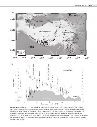
            Figure 10.16  (a) GPS velocity field relative to stable Siberia (image provided by Y. Yang and M. Liu and modified
            from Liu & Yang, 2003, by permission of the American Geophysical Union. Copyright © 2003 American Geophysical
            Union), combining data from Chen et al. (2000), Larson et al. (1999), and Wang et al. (2001). Error ellipses are 95%

            confidence. Velocity scale is shown in lower left corner. (b) GPS velocity profile across the Tibetan Plateau in the

            direction N21°E (after Wang et al., 2001, Science 294, 574–7, with permission from the AAAS). Black diamonds represent
            the component of velocity perpendicular to the profile, light gray diamonds represent the component of the velocity


            parallel to the profile.
   323   324   325   326   327   328   329   330   331   332   333