
Page 329 - Global Tectonics
P. 329
312 CHAPTER 10
Eurasia
40 N Tarim Basin
o
Qaidam
Basin
35 N
o
Tibetan Plateau
Songpan-Ganzi
30 N Sichuan
o
Basin
Himalaya
India
25 N
o
South
China
70 E 75 E 80 E 85 E 90 E 95 E 100 E 105 E 110 E
o
o
o
o
o
o
o
o
o
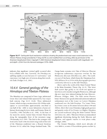
Figure 10.17 Earthquake focal mechanism solutions showing the predominant east–west crustal extension in the
Tibetan Plateau (image provided by Y. Yang and M. Liu and modified from Liu & Yang, 2003, by permission of the
American Geophysical Union. Copyright © 2003 American Geophysical Union). Data are events with magnitude >5.5
and depth <33 km from the Harvard catalogue (1976–2000).
indicates that significant vertical uplift occurred after Ganga basin contains over 5 km of Miocene–Pliocene
India collided with Asia. Currently, the Himalaya are terrigenous sedimentary sequences overlain by late
−1
uplifting rapidly at rates between 0.5 and 4 mm a and Pleistocene alluvium (DeCelles et al., 2001). The north-
experience very high rates of erosion along their south- ern part of this basin, which forms the Himalayan foot-
ern fl ank (Hodges et al., 2001). hills, defines a 10- to 25-km-wide physiographic province
commonly referred to as the Sub-Himalaya.
Above and to the north of the Main Frontal Thrust
10.4.4 General geology of the is the Main Boundary Thrust (Fig. 10.19). This latter
fault system dips gently to the north and appears to
Himalaya and Tibetan Plateau have been active mostly during the Pleistocene, although
slip on it may have initiated during the Late Miocene–
The Himalaya are composed of three large, imbricated Pliocene (Hodges, 2000). The fault carries Precam-
thrust slices and related folds separated by four major brian–Mesozoic low-grade schist and unmetamorphosed
fault systems (Figs 10.19, 10.20). These imbricated sedimentary rock of the Lesser (or Lower) Himalaya
thrusts, which occupy a section about 250–350 km wide, southward over the Sub-Himalaya. The Lesser Hima-
appear to accommodate approximately one-third to laya form a zone at elevations between about 1500 and
one-half of the ∼2000 or more kilometers of post-col- 3000 m. Above the Lesser Himalaya, high-grade gneisses
lisional shortening between India and Eurasia (Besse & and granitic rocks of the Greater (or Higher) Himalaya
Courtillot, 1988; DeCelles et al., 1998). At the base of are carried southward along the Main Central Thrust
the stack the mostly buried Main Frontal Thrust lies (DeCelles et al., 2001). This latter thrust accommodated
along the topographic front of the mountain range significant shortening during the Early Miocene and
(Wesnousky et al. 1999). This fault is the youngest and Pliocene, and appears inactive in most places today
most active fault in the mountain range and carries rock (Hodges, 2000).
of the Himalaya southward into a fl exural foredeep The Greater Himalaya, which reach altitudes of
(Section 10.3.2) called the Ganga foreland basin. The over 8000 m, consist of Precambrian gneiss overlain by