
Page 400 - Global Tectonics
P. 400
382 CHAPTER 12
12.3.2 Calculation of the sion on a sphere, for different values of the Earth’s
radius. The radius for which the dispersion of the poles
ancient radius of the Earth is a minimum is taken to be the best estimate of the
paleoradius. McElhinny et al. (1978) analyzed the paleo-
A rather less involved method of testing the expanding magnetic data available at that time using this method.
Earth hypothesis entails determining the paleoradius They found that for the past 400 Ma the average paleo-
of the Earth using paleomagnetic techniques (Egyed, radius has been 102 ± 2.8% of the present radius. A
1960). small contraction or very slight expansion of the Earth
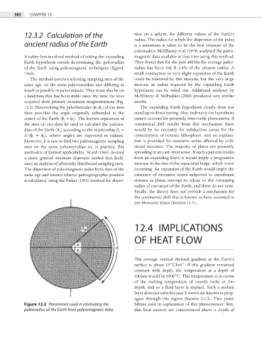
The method involves selecting sampling sites of the could be tolerated by this analysis, but the very large
same age, on the same paleomeridian and differing as increase in radius required by the expanding Earth
much as possible in paleolatitude. They must also be on hypothesis can be ruled out. Additional analyses by
a landmass that has been stable since the time the sites McElhinny & McFadden (2000) produced very similar
acquired their primary remanent magnetizations (Fig. results.
12.2). Determining the paleolatitudes (φ 1 ,φ 2 ) of the sites The expanding Earth hypothesis clearly does not
then provides the angle originally subtended at the stand up to direct testing. Also, indirectly the hypothesis
center of the Earth (φ 1 + φ 2 ). The known separation of cannot account for presently observable phenomena. If
the sites (d) can then be used to calculate the paleora- continental drift results from this mechanism there
dius of the Earth (R a ) according to the relationship R a = would be no necessity for subduction zones for the
d/(φ 1 + φ 2 ), where angles are expressed in radians. consumption of oceanic lithosphere, and no explana-
However, it is rare to find two paleomagnetic sampling tion is provided for extensive zones affected by colli-
sites on the same paleomeridian so, in practice, this sional tectonics. The majority of plates are presently
method is of limited applicability. Ward (1963) devised spreading in an east–west sense. If such a pattern results
a more general minimum dispersion method that facili- from an expanding Earth it would imply a progressive
tates an analysis of arbitrarily distributed sampling sites. increase in the size of the equatorial bulge, which is not
The dispersion of paleomagnetic poles from sites of the occurring. An expansion of the Earth would imply the
same age and known relative paleogeographic position existence of extensive zones subjected to membrane
is calculated, using the Fisher (1953) method for disper- stresses as plates attempt to adjust to the increasing
radius of curvature of the Earth, and these do not exist.
Finally, the theory does not provide a mechanism for
the continental drift that is known to have occurred in
pre-Mesozoic times (Section 11.5).
12.4 IMPLICATIONS
OF HEAT FLOW
The average vertical thermal gradient at the Earth’s
−1
surface is about 25°C km . If this gradient remained
constant with depth, the temperature at a depth of
100 km would be 2500°C. This temperature is in excess
of the melting temperature of mantle rocks at this
depth, and so a fluid layer is implied. Such a molten
layer does not exist because S waves are known to prop-
agate through this region (Section 2.1.3). Two possi-
Figure 12.2 Parameters used in estimating the bilities exist in explanation of this phenomenon: fi rst,
paleoradius of the Earth from paleomagnetic data. that heat sources are concentrated above a depth of