
Page 210 - Geology and Geochemistry of Oil and Gas
P. 210
CLASSIFICATION OF HYDROCARBON ACCUMULATIONS 179
The above discussion may explain the unsuccessful oil and gas exploration efforts
at great depths in many cases. Usually, the wells have been drilled over the crests of
the structures that may not be the best location for finding ‘‘critical-state’’ accu-
mulations, in the absence of fluid gravity separation. Most often, the well tests have
been conducted in sandstones. Yet, the reservoir rocks of the ‘‘critical-state’’ accu-
mulations may be argillaceous rocks, whereas the sandstones may have acted as
seals. Large pressure drawdown had been usually applied to cause the flow of fluids,
which may have closed the flow channels (pore throats and canals) around the
borehole due to the overburden pressure. In the case of fluid flow, an attempt is
made to maintain the pressure (which was already much higher than critical),
whereas the temperature should have been maintained.
The above discussion may explain the well test results in superdeep wells (around
30,000 ft or 10,000 m), i.e., mostly weak flows of gas-cut water (sometimes oil-cut)
have been obtained. Inasmuch as the temperature and pressure change near the
boreholes, the flow conditions change (fractures close) and different phases separate
out. Thus, the main exploration tools are based on the state of system and its energy,
and the measurements of density, electric conductivity, seismic velocity, etc., may
become very important. A further subsidence of the accumulation, at very high
temperatures and pressures will result in the total decomposition of the system. It is
difficult to estimate the temperature at which this may occur; it may reach more than
10001C at pressures of hundreds of MPa’s.
As far as the classification of oil accumulations based on the phase transforma-
tions are concerned, two branches are present that merge in the ‘‘critical-state’’
accumulations.
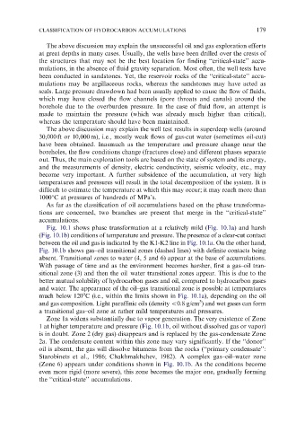
Fig. 10.1 shows phase transformation at a relatively mild (Fig. 10.1a) and harsh
(Fig. 10.1b) conditions of temperature and pressure. The presence of a clear-cut contact
between the oil and gas is indicated by the K1-K2 line in Fig. 10.1a. On the other hand,
Fig. 10.1b shows gas–oil transitional zones (dashed lines) with definite contacts being
absent. Transitional zones to water (4, 5 and 6) appear at the base of accumulations.
With passage of time and as the environment becomes harsher, first a gas–oil tran-
sitional zone (3) and then the oil–water transitional zones appear. This is due to the
better mutual solubility of hydrocarbon gases and oil, compared to hydrocarbon gases
and water. The appearance of the oil–gas transitional zone is possible at temperatures
o
much below 120 C (i.e., within the limits shown in Fig. 10.1a), depending on the oil
3
and gas composition. Light paraffinic oils (density o0.8 g/cm ) and wet gases can form
a transitional gas–oil zone at rather mild temperatures and pressures.
Zone 1a widens substantially due to vapor generation. The very existence of Zone
1 at higher temperature and pressure (Fig. 10.1b, oil without dissolved gas or vapor)
is in doubt. Zone 2 (dry gas) disappears and is replaced by the gas-condensate Zone
2a. The condensate content within this zone may vary significantly. If the ‘‘donor’’
oil is absent, the gas will dissolve bitumens from the rocks (‘‘primary condensate’’:
Starobinets et al., 1986; Chakhmakhchev, 1982). A complex gas–oil–water zone
(Zone 6) appears under conditions shown in Fig. 10.1b. As the conditions become
even more rigid (more severe), this zone becomes the major one, gradually forming
the ‘‘critical-state’’ accumulations.