
Page 292 - Hydrogeology Principles and Practice
P. 292
HYDC07 12/5/05 5:33 PM Page 275
Groundwater pollution remediation and protection 275
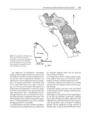
Fig. 7.12 Groundwater vulnerability map
for the lower Walawe river basin, Sri
Lanka, derived qualitatively with regard to
the locally important human health risk
parameters of fluoride, arsenic and nitrate
in groundwater from dug wells and tube
wells. After Rajasooriyar (2003).
The application of groundwater vulnerability the fractured Highland Series and less fractured
mapping using available information and scientific Eastern Vijayan Complex).
knowledge is a valuable aid in educating people about 2 Hydrogeological factors: shallow regolith (weath-
the potential risks of groundwater pollution and ered) aquifers; deep, hard rock (fractured) aquifers
explaining the need for appropriate land-use manage- with low/moderate and high transmissivity zones.
ment. An example groundwater vulnerability map 3 Recharge conditions: areas subject to low rainfall
for the Uda Walawe basin in Sri Lanka is shown in recharge only; areas subject to high rainfall and irriga-
Fig. 7.12. The map was developed with regard to the tion recharge.
locally important risk parameters of fluoride, arsenic 4 Salt water mixing: areas close to the coast subject
and nitrate in groundwater from dug wells and tube to saline intrusion and sea-salt spray; unaffected areas
wells (Rajasooriyar 2003). Microbiological factors, away from the coast.
although important, were not included in the deriva- Interestingly, it was found that nitrate and phosphate
tion of the map due to insufficient information. The do not pose an immediate groundwater pollution
following factors were combined, using expert judge- risk in areas of banana and paddy cultivation in the
ment, to classify qualitatively areas as low, medium Highland Series and Eastern Vijayan Complex regions,
and high groundwater vulnerability: even though these crops are subject to irrigation
1 Geological factors: mineralogy (fluoride- and arsenic- recharge and the application of large amounts of
bearing minerals); geological structure (divided into fertilizer input. It appears that denitrification occurs