
Page 299 - Hydrogeology Principles and Practice
P. 299
HYDC08 12/5/05 5:31 PM Page 282
282 Chapter Eight
from beneath the Libyan desert and its transfer to
coastal cities and towns. Clearly the groundwater
supply is not a permanent, renewable resource but
for a period of at least decades this fossil water can
supply most of the population of Libya with an essen-
tial resource. As argued by Price (2002), the GMRP
appears to meet the ethical requirements of ground-
water mining, namely that: (i) evidence is available
that pumping can be maintained for a long period;
(ii) the negative impacts of development are smaller
than the benefits; and (iii) the users and decision-
makers are aware that the resource will be eventually
depleted. However, Price (2002) is concerned that
using non-renewable groundwater for inefficient
agriculture in a region where there is effectively no
recharge is not a sensible long-term plan.
8.2.3 Regional-scale groundwater
development schemes
The above two examples of large-scale groundwater
developments in support of irrigated agriculture tip
the sustainability equation towards economic gain.
At the regional scale, effective river basin management
can develop the large storage volume in aquifers in
conjunction with surface resources. This concept is
not new and several schemes, principally the Thames,
Great Ouse, Severn, Itchen and Waveney Schemes,
were developed in England and Wales following
the Water Resources Act of 1963 (see Section 1.7).
Pilot studies were undertaken to assess the feasibility
of regulating rivers by pumping groundwater into
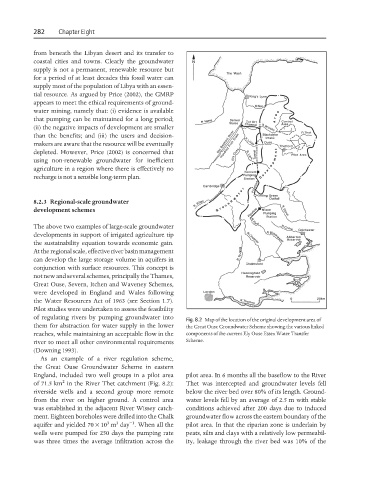
Fig. 8.2 Map of the location of the original development area of
them for abstraction for water supply in the lower the Great Ouse Groundwater Scheme showing the various linked
reaches, while maintaining an acceptable flow in the components of the current Ely Ouse Essex Water Transfer
river to meet all other environmental requirements Scheme.
(Downing 1993).
As an example of a river regulation scheme,
the Great Ouse Groundwater Scheme in eastern
England, included two well groups in a pilot area pilot area. In 6 months all the baseflow to the River
2
of 71.5 km in the River Thet catchment (Fig. 8.2): Thet was intercepted and groundwater levels fell
riverside wells and a second group more remote below the river bed over 80% of its length. Ground-
from the river on higher ground. A control area water levels fell by an average of 2.5 m with stable
was established in the adjacent River Wissey catch- conditions achieved after 200 days due to induced
ment. Eighteen boreholes were drilled into the Chalk groundwater flow across the eastern boundary of the
3
−1
3
aquifer and yielded 70 × 10 m day . When all the pilot area. In that the riparian zone is underlain by
wells were pumped for 250 days the pumping rate peats, silts and clays with a relatively low permeabil-
was three times the average infiltration across the ity, leakage through the river bed was 10% of the