
Page 393 - Introduction to AI Robotics
P. 393
376
11
Localization and Map Making
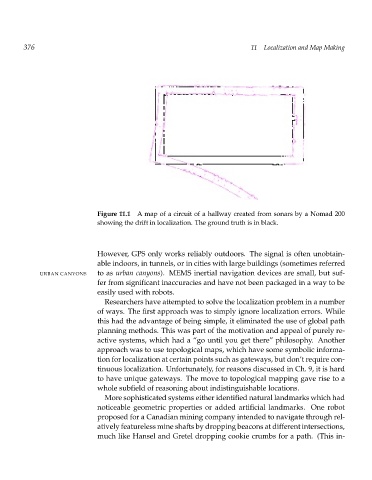
Figure 11.1 A map of a circuit of a hallway created from sonars by a Nomad 200
showing the drift in localization. The ground truth is in black.
However, GPS only works reliably outdoors. The signal is often unobtain-
able indoors, in tunnels, or in cities with large buildings (sometimes referred
URBAN CANYONS to as urban canyons). MEMS inertial navigation devices are small, but suf-
fer from significant inaccuracies and have not been packaged in a way to be
easily used with robots.
Researchers have attempted to solve the localization problem in a number
of ways. The first approach was to simply ignore localization errors. While
this had the advantage of being simple, it eliminated the use of global path
planning methods. This was part of the motivation and appeal of purely re-
active systems, which had a “go until you get there” philosophy. Another
approach was to use topological maps, which have some symbolic informa-
tion for localization at certain points such as gateways, but don’t require con-
tinuous localization. Unfortunately, for reasons discussed in Ch. 9, it is hard
to have unique gateways. The move to topological mapping gave rise to a
whole subfield of reasoning about indistinguishable locations.
More sophisticated systems either identified natural landmarks which had
noticeable geometric properties or added artificial landmarks. One robot
proposed for a Canadian mining company intended to navigate through rel-
atively featureless mine shafts by dropping beacons at different intersections,
much like Hansel and Gretel dropping cookie crumbs for a path. (This in-