
Page 198 - Introduction to Mineral Exploration
P. 198
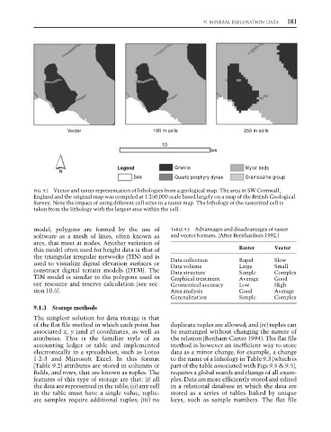
9: MINERAL EXPLORATION DATA  181


                            Vector                      100 m cells                   250 m cells
                                                           10
                                                                           km

                                             Legend            Granite                Mylor beds
                          N
                                                  Sea          Quartz porphyry dykes  Gramscatho group

                 FIG. 9.2 Vector and raster representation of lithologies from a geological map. The area in SW Cornwall,
                 England and the original map was compiled at 1:250,000 scale based largely on a map of the British Geological
                 Survey. Note the impact of using different cell sizes in a raster map. The lithology of the rasterized cell is
                 taken from the lithology with the largest area within the cell.


                 model, polygons are formed by the use of     TABLE 9.2 Advantages and disadvantages of raster
                 software as a mesh of lines, often known as  and vector formats. (After Bernhardsen 1992.)
                 arcs, that meet at nodes. Another variation of
                 this model often used for height data is that of                   Raster     Vector
                 the triangular irregular networks (TIN) and is
                 used to visualize digital elevation surfaces or  Data collection   Rapid      Slow
                                                                                               Small
                                                              Data volume
                                                                                    Large
                 construct digital terrain models (DTM). The  Data structure        Simple     Complex
                 TIN model is similar to the polygons used in  Graphical treatment  Average    Good
                 ore resource and reserve calculation (see sec-  Geometrical accuracy  Low     High
                 tion 10.5).                                  Area analysis         Good       Average
                                                              Generalization        Simple     Complex
                 9.1.3 Storage methods
                 The simplest solution for data storage is that
                 of the flat file method in which each point has  duplicate tuples are allowed; and (iv) tuples can
                 associated x, y (and z) coordinates, as well as  be rearranged without changing the nature of
                 attributes. This is the familiar style of an  the relation (Bonham-Carter 1994). The flat file
                 accounting ledger or table and implemented   method is however an inefficient way to store
                 electronically in a spreadsheet, such as Lotus  data as a minor change, for example, a change
                 1-2-3 and Microsoft Excel. In this format    to the name of a lithology in Table 9.3 (which is
                 (Table 9.2) attributes are stored in columns or  part of the table associated with Figs 9.4 & 9.5),
                 fields, and rows, that are known as tuples. The  requires a global search and change of all exam-
                 features of this type of storage are that: (i) all  ples. Data are more efficiently stored and edited
                 the data are represented in the table; (ii) any cell  in a relational database in which the data are
                 in the table must have a single value, replic-  stored as a series of tables linked by unique
                 ate samples require additional tuples; (iii) no  keys, such as sample numbers. The flat file