
Page 123 - Introduction to Petroleum Engineering
P. 123
ROCKS AND FORMATIONS 109
(a) (b)
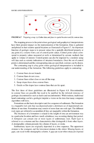
FIGURE 6.7 Preparing a map. (a) Gather data and place in spatial location and (b) contour data.
The mapping process is the point where geological and geophysical interpretations
have their greatest impact on the representation of the formation. Data is gathered
and plotted in their relative spatial locations as illustrated in Figure 6.7. An important
function of geologic maps is to present values for a spatially distributed property at
any point in a volume from a set of control point values. Control point values corre-
spond to property values measured at wells or determined by seismic methods that
apply to volume of interest. Control points can also be imposed by a modeler using
soft data such as seismic indications of structure boundaries. Once the set of control
points is determined and the corresponding data are specified, contours can be drawn.
The contouring step is a key point where geological interpretation is included in
our understanding of the formation. The following guidelines apply to contouring:
1. Contour lines do not branch.
2. Contour lines do not cross.
3. Contour lines either close or run off the map.
4. Steep slopes have close contour lines.
5. Gentle or flat slopes have contour lines that are far apart.
The first three of these guidelines are illustrated in Figure 6.8. Discontinuities
in contour lines are possible but need to be justified by the inferred existence of
geologic discontinuities such as faults and unconformities. While tedious, traditional
hand contouring can let a geologist imprint a vision on the data that many computer
algorithms will miss.
Formations are the basic descriptive unit for a sequence of sediments. The formation
is a mappable rock unit that was deposited under a dominant set of depositional con-
ditions at one time. Formations may consist of more than one rock type. The different
rock types are referred to as members if they are mappable within the formation.
The thickness of a formation is related to the length of time an environment was
in a particular location and how much subsidence was occurring during that period.
A formation can contain one or more layers of sedimentary rock. Each layer is
referred to as a stratum and has characteristics that distinguish it from other layers.
A stratigraphic column presents the column of layers, or strata.
Sedimentary layers are originally deposited in a time sequence. The uppermost
stratum is the youngest, and the lowermost stratum is the oldest. Missing layers, or
gaps, can occur in the stratigraphic column. A gap can occur when strata are exposed