
Page 193 - Laboratory Manual in Physical Geology
P. 193
A CTIVIT Y 6.2 Mount Rainier Sediment Analysis
Name: ______________________________________ Course/Section: ______________________ Date: ___________
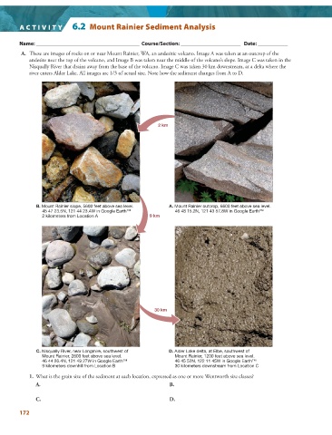
A. These are images of rocks on or near Mount Rainier, WA, an andesitic volcano. Image A was taken at an outcrop of the
andesite near the top of the volcano, and Image B was taken near the middle of the volcano’s slope. Image C was taken in the
Nisqually River that drains away from the base of the volcano. Image C was taken 30 km downstream, at a delta where the
river enters Alder Lake. All images are 1/3 of actual size. Note how the sediment changes from A to D.
2 km
B. Mount Rainier slope, 5600 feet above sea level. A. Mount Rainier outcrop, 6600 feet above sea level.
45 47 23.5N, 121 44 23.4W in Google Earth™ 46 48 15.2N, 121 43 57.8W in Google Earth™
2 kilometers from Location A 9 km
30 km
C. Nisqually River, near Longmire, southwest of D. Alder Lake delta, at Elbe, southwest of
Mount Rainier, 2600 feet above sea level. Mount Rainier, 1200 feet above sea level.
46 44 26.4N, 121 49 27W in Google Earth™ 46 45 52N, 122 11 45W in Google Earth™
9 kilometers downhill from Location B 30 kilometers downstream from Location C
1. What is the grain size of the sediment at each location, expressed as one or more Wentworth size classes?
A. B.
C. D.
172