
Page 305 - Laboratory Manual in Physical Geology
P. 305
ACTIVITY 10.3 Map Contacts and Formations
Name: ______________________________________ Course/Section: ______________________ Date: ___________
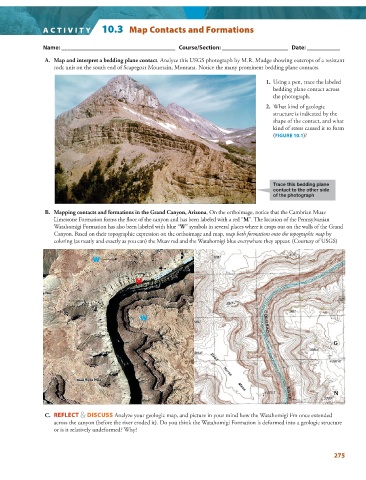
A. Map and interpret a bedding plane contact . Analyze this USGS photograph by M.R. Mudge showing outcrops of a resistant
rock unit on the south end of Scapegoat Mountain, Montana. Notice the many prominent bedding plane contacts.
1. Using a pen, trace the labeled
bedding plane contact across
the photograph.
2. What kind of geologic
structure is indicated by the
shape of the contact, and what
kind of stress caused it to form
( FIGURE 10.1 )?
Trace this bedding plane
contact to the other side
of the photograph
B. Mapping contacts and formations in the Grand Canyon, Arizona . On the orthoimage, notice that the Cambrian Muav
Limestone Formation forms the floor of the canyon and has been labeled with a red “ M ”. The location of the Pennsylvanian
Watahomigi Formation has also been labeled with blue “ W ” symbols in several places where it crops out on the walls of the Grand
Canyon. Based on their topographic expression on the orthoimage and map, map both formations onto the topographic map by
coloring (as neatly and exactly as you can) the Muav red and the Watahomigi blue everywhere they appear. (Courtesy of USGS)
W W
M M
W W
C. REFLECT & DISCUSS Analyze your geologic map, and picture in your mind how the Watahomigi Fm once extended
across the canyon (before the river eroded it). Do you think the Watahomigi Formation is deformed into a geologic structure
or is it relatively undeformed? Why?
275