Page 412 - Laboratory Manual in Physical Geology
P. 412

A
                                                                  East                               West


                                                                            Saltmarsh                Saltmarsh
                                                                              mud
                                                                 Ocean


                                                                               Sand


                                           A
                     St. Catherines
                     Island            C
                                                                                                            B
                                                                  East                               West
                                               B


                                                                    Saltmarsh
                                                                      mud
                                                               Ocean                             Saltmarsh


                                                                              Sand


                                                                                                            C
                                                                  East                               West


                                                    N
                                                                Ocean

                                    0    1 km
                                                                                Sand

                                                                                           Saltmarsh


                  Sand        Salt marsh   Salt marsh mud


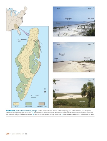
          FIGURE 15.5    St. Catherines Island, Georgia.        Notice the distribution of sand, salt marsh (living), and salt marsh mud, plus the points
        where the three photographs were taken.   A. View south–southeast from point  A  on map, at low tide. Dark-brown “ribbon” adjacent to ocean is


        salt marsh mud. Light-colored area is sand.   B.  View south from point  B  on map at low tide.  C. View southeast from point  C  (Aaron’s Hill) on map.


        380  ■  L ABOR ATORY  15
   407   408   409   410   411   412   413   414   415   416   417