
Page 281 - Modern Spatiotemporal Geostatistics
P. 281
262 Modern Spatiotemporal Geostatistics — Chapter 12
depth to water table, sources/sinks, topographic contours, etc.), and
the goals of the study (preventing outbreaks of contamination, optimal
sampling design, remediation strategy, etc.).
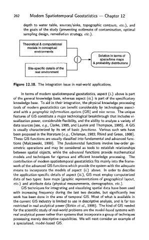
Figure 12.18. The integration issue in real-world applications.
In terms of modern spatiotemporal geostatistics, aspect (i.) above is part
of the general knowledge base, whereas aspect («.) is part of the specificatory
knowledge base. To aid in their integration, the physical knowledge processing
tools of modern geostatistics can benefit considerably by technologies associ-
ated with a geographic information system (CIS) and vice versa. The unique
features of CIS constitute a major technological breakthrough that includes vi-
sualization power, considerable flexibility, and the ability to analyze a variety of
data sources (see, e.g., Clarke, 1986, and Laurini and Thompson, 1995). A CI
is usually characterized by its set of basic functions. Various such sets have
been proposed in the literature (e.g., Chrisman, 1983; Rhind and Green, 1988).
These CIS functions are usually classified into fundamental and advanced func-
tions (Malczewski, 1999). The fundamental functions involve low-order ge-
ometric operations and may be considered as tools to establish relationships
between spatial objects, while the advanced functions provide mathematical
models and techniques for rigorous and efficient knowledge processing. The
contribution of modern spatiotemporal geostatistics fits mainly into the frame-
work of the advanced CIS functions which provide the system with the adequate
means to incorporate the models of aspect (i.) above. In order to describe
the application-specific details of aspect (ii.), CIS must employ computerized
data of two types: base maps (graphic representations of geographical layout,
etc.) and attribute data (physical measurements, demographics, etc.).
CIS techniques for integrating and visualizing spatial data have been used
with increasing frequency during the last two decades, but significantly less
work has been done in the area of temporal CIS. Most of what is available in
the current CIS industry is limited to use in descriptive analysis, and is far too
restricted in real analytical power (Birkin et al., 1996). The kind of CIS needed
for the scientific study of real-world problems are the model-based systems with
real analytical power rather than systems that incorporate a group of techniques
possessing merely descriptive capabilities. We will next consider an example of
a specialized, model-based CIS.