
Page 282 - Modern Spatiotemporal Geostatistics
P. 282
Popular Methods in the Light of Modern Geostatistics 263
EXAMPLE 12.20: Geographical plume analysis (Osleeb and Kahn, 1999) is an
analytical tool which consists of a chemical dispersion model that is integrated
with a CIS. Dispersion models take into account information about weather
conditions, pollutant type and amount, plume characteristics, etc., which is
used to predict the spatial distribution of the pollutant concentrations. This
spatial distribution is then combined with a site-specific CIS database to assess
its effects on the local environment.
Conceptual models of the natural phenomenon under consideration are
often needed to guide the various stages of CIS analysis. This is the case of
the following example.
EXAMPLE 12.21: Mineral deposit models are conceptual models which describe
the main properties of deposits belonging to the same group (stratigraphy, dikes
and fractures, genesis and deposit formation processes, etc.). Such models can
provide the theoretical framework for guiding CIS studies of mineral potential
(Bonham-Carter, 1994).
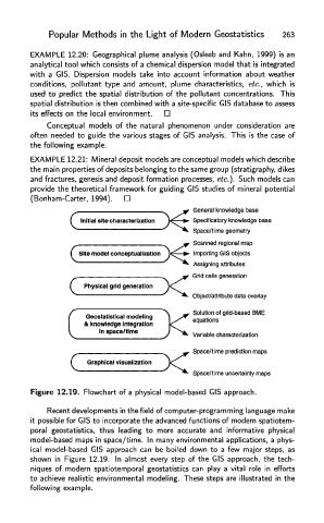
Figure 12.19. Flowchart of a physical model-based CIS approach.
Recent developments in the field of computer-programming language mak
it possible for CIS to incorporate the advanced functions of modern spatiotem-
poral geostatistics, thus leading to more accurate and informative physical
model-based maps in space/time. In many environmental applications, a phys-
ical model-based CIS approach can be boiled down to a few major steps, as
shown in Figure 12.19. In almost every step of the CIS approach, the tech-
niques of modern spatiotemporal geostatistics can play a vital role in efforts
to achieve realistic environmental modeling. These steps are illustrated in the
following example.