
Page 291 - Petroleum Geology
P. 291
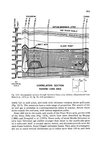
265

                         RAINBOW                                              ZAMA
                                                                              Pn
              v)
              p:
              e”t;
              WIIl
              ILL


                                                        SLAVE  POINT


               NO
            HORIZONTAL
              SCALE                CORRELATlON  SECTION
                                     RAINBW-ZAMA  AREA


            Fig.  12-6. Stratigraphic  section through Rainbow-Zama area, Alberta. (Reproduced from
            Barss et at., 1970, p. 42, fig. 20, with permission.)

            nearly full to spill point, and reefs with  oil/water contacts above spill point
            (Fig. 12-7). The reservoirs have a wide range of properties. The source of the
            oil  and  gas is probably  in contemporaneous strata in euxinic, deeper water
            facies outside the reef area, with various migration paths.
              Some 400 km to the south, and south of the Peace River arch, are the reefs
            of  the  Swan  Hills  area  (Fig.  12-8), which  have  been  described  by Murray
            (1966) and Hemphill et al. (1970). These reefs, of latest Middle Devonian to
            early Late Devonian age (rather younger than those to the north) also grew
            op a carbonate shelf  in normal marine waters, and stromatoporoids were the
            main frame builders. Some fringed carbonate banks. They grew in a transgres-
            sive sea to reach vertical thicknesses up to rather more than 100 m, and their