
Page 292 - Petroleum Geology
P. 292
266
growth was terminated by drowning, probably rather earlier in the north
than in the south (Murray, 1966). Naturally, the transgression was locally to
the north against the Peace River arch. Deeper-water sediments of the Water-
ways Formation lie to the east and the north of the Swan Hills reefs, and are
thought by some to be the source of the petroleum. The reefs and their asso-
ciated banks have not been dolomitized. The area is virtually devoid of struc-
tural deformation, and the regional dip is about lJLo to the south-west.
The reefs of the Swan Hills area form two-parallel trends, each with gas in
the down-dip reef. This suggests differential entrapment, and therefore a
source down-dip to the south-west of the area. In the Kaybob-Snipe trend,
the oil gravity changes progressively from 43"API in Kaybob, through 40" in
Goose River, to 37" in Snipe Lake. No marked change of gravity is found in
the other trend, but a point of interest is that both pools in the Carson Creek
North have a small gas cap on undersaturated oil (Hemphill et al., 1970,
p. 83). The crudes are all paraffin base, undersaturated, with a low sulphur
content (< 5%).
Porosity and permeability are both rather low in these fields, the average
porosity being between 6 and lo%, and permeability between 5 and 170 md.
SULPHUR R
MUSKEG
BLACK CR.
KEG RIVER
551 753 806 760 786 800 649 695
90 579 615 41 360 554 43 I 316
400 550 3640 481 5
64 104 565 306 40 5 223 308 ~
3.2 6.2 10.6 7.2 13.2 4.6 4.5
3.5 434 16 274 36 218 44.5
803 756 672 714 RAINBOW MEMBER
5 92 686 3 50 I60
985 767 875 RESERVOIR CHARACTERISTICS
I26 37 90 1000
10 11.8 7.6 3,
29.5 164 72.7 9.7.
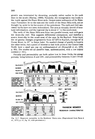
Fig. 12-7. Reservoir variability in the Rainbow-Zama area. (Reproduced from Barss et
al., 1970, p. 47, fig. 25, with permission.)