
Page 111 - Principles of Applied Reservoir Simulation 2E
P. 111
96 Principles of Applied Reservoir Simulation
Core and well log information gives us a very limited view of the res-
ervoir. A seismic section expands the fraction of area sampled, but the interpreta-
tion of seismic data is less precise. Seismic data is often viewed as "soft data"
because of its dependence on interpretation. The reliability of seismic interpreta-
tion can be improved when correlated with "hard data" such as core and well
log measurements.
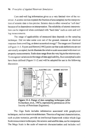
The range of applicability of measured data depends on the sampling
technique. Did we take some core out of the ground, measure an electrical
response from a well log, or detect acoustical energy? The ranges are illustrated
in Figure 11-1. Payers and Hewett [ 1992] point out that scale definitions are not
universally accepted, but do illustrate the relative scale associated with reservoir
property measurements. Scale sizes range from the very big to the microscopic.
To recognize variations in the range of data applicability, four conceptual scales
have been defined (Figure 11-2) and will be adopted for use in the following
discussion.
WELL COR ELECTRIC LOG SEISMIC SECTION
100* -ISO'
49m
-150'
Figure 11-1. Range of data sampling techniques (after
Richardson, et al., 1987a; reprinted by permission of the
Society of Petroleum Engineers).
The Giga Scale includes information associated with geophysical
techniques, such as reservoir architecture. Theories of regional characterization,
such as plate tectonics, provide an intellectual framework within which Giga
Scale measurement techniques, like seismic and satellite data, can be interpreted.
The Mega Scale is the scale of reservoir characterization and includes well