
Page 110 - Satellite Communications, Fourth Edition
P. 110
90 Chapter Three
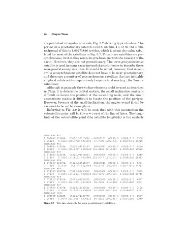
are published at regular intervals, Fig. 3.7 showing typical values. The
period for a geostationary satellite is 23 h, 56 min, 4 s, or 86,164 s. The
reciprocal of this is 1.00273896 rev/day, which is about the value tabu-
lated for most of the satellites in Fig. 3.7. Thus these satellites are geo-
synchronous, in that they rotate in synchronism with the rotation of the
earth. However, they are not geostationary. The term geosynchronous
satellite is used in many cases instead of geostationary to describe these
near-geostationary satellites. It should be noted, however, that in gen-
eral a geosynchronous satellite does not have to be near-geostationary,
and there are a number of geosynchronous satellites that are in highly
elliptical orbits with comparatively large inclinations (e.g., the Tundra
satellites).
Although in principle the two-line elements could be used as described
in Chap. 2 to determine orbital motion, the small inclination makes it
difficult to locate the position of the ascending node, and the small
eccentricity makes it difficult to locate the position of the perigee.
However, because of the small inclination, the angles w and Ω can be
assumed to be in the same plane.
Referring to Fig. 2.9 it will be seen that with this assumption the
subsatellite point will be east of the line of Aries. The longi-
tude of the subsatellite point (the satellite longitude) is the easterly
INTELSAT 901
1 26824U 01024A 05122.92515626 -.00000151 00000-0 10000-3 0 7388
2 26824 0.0158 338.7780 0004091 67.7508 129.4375 1.00270746 14318
INTELSAT 902
1 26900U 01039A 05126.99385197 .00000031 00000-0 10000-3 0 6260
2 26900 0.0156 300.5697 0002640 112.8823 231.2391 1.00271845 13528
INTELSAT 903
1 27403U 02016A 05125.03556931 .00000000 00000-0 10000-3 0 6249
2 27403 0.0362 171.6123 0002986 232.5077 157.1571 1.00265355 11412
INTELSAT 904
1 27380U 02007A 05125.62541657 .00000043 00000-0 00000+0 0 5361
2 27380 0.0202 0.0174 0003259 40.3723 108.3316 1.00272510 11761
INTELSAT 905
1 27438U 02027A 05125.03693822 .00000000 00000-0 10000-3 0 5812
2 27438 0.0205 164.2424 0002820 218.0675 189.4691 1.00265924 10746
INTELSAT 906
1 27513U 02041A 05126.63564565 .00000012 00000-0 00000+0 0 4817
2 27513 0.0111 324.7901 0003200 99.2828 93.4848 1.00272600 9803
INTELSAT 907
1 27683U 03007A 05124.32309516 .00000000 00000-0 10000-3 0 3108
2 27683 0.0206 13.5522 0009594 61.6856 235.7624 1.00266570 8131
INTELSAT 1002
1 28358U 04022A 05124.94126775 -.00000018 00000-0 00000+0 0 1527
2 28358 0.0079 311.0487 0000613 59.4312 190.2817 1.00271159 3289
Figure 3.7 Two-line elements for some geostationary satellites.