
Page 34 - Satellite Communications, Fourth Edition
P. 34
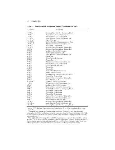
14   Chapter One

                              TABLE 1.6 Ka-Band Orbital Assignment Plan (FCC December 19, 1997)
                              Location                       Company
                              147°W.L.            Morning Star Satellite Company, L.L.C.
                              125°W.L.            PanAmSat Licensee Corporation
                              121°W.L.            Echostar Satellite Corporation
                              115°W.L.            Loral Space & Communications, Ltd.
                                    ∗
                              113°W.L.            VisionStar, Inc.
                              109.2°W.L.          KaStar Satellite Communications Corp.
                              105°W.L. †          GE American Communications, Inc.
                              103°W.L.            PanAmSat Corporation
                              101°W.L.            Hughes Communications Galaxy, Inc.
                              99°W.L.             Hughes Communications Galaxy, Inc.
                              97°W.L.             Lockheed Martin Corporation
                              95°W.L.             NetSat 28 Company, L.L.C.
                              93°W.L.             Loral Space & Communications, Ltd.
                              91°W.L.             Comm, Inc.
                              89°W.L.             Orion Network Systems
                              87°W.L.             Comm, Inc.
                              85°W.L.             GE American Communications, Inc.
                              83°W.L.             Echostar Satellite Corporation
                              81°W.L.             Orion Network Systems
                              77°W.L.             Comm, Inc.
                              75°W.L.             Comm, Inc.
                              73°W.L.             KaStar Satellite Corporation
                              67°W.L.             [under consideration]
                              62°W.L.             Morning Star Satellite Company, L.L.C.
                              58°W.L.             PanAmSat Corporation
                              49°W.L.             Hughes Communications Galaxy, Inc.
                              47°W.L.             Orion Atlantic, L.P.
                              21.5°W.L.           Lockheed Martin Corporation
                              17°W.L.             GE American Communications, Inc.
                              2°E.L.              Lockheed Martin Corporation
                              25°E.L.             Hughes Communication Galaxy, Inc.
                              30°E.L.             Morning Star Satellite Company, L.L.C.
                              36°E.L.             PanAmSat Corporation
                              40°E.L.             PanAmSat Corporation
                              48°E.L.             PanAmSat Corporation
                              54°E.L.             Hughes Communications Galaxy, Inc.
                              56°E.L.             GE American Communications, Inc.
                              78°E.L.             Orion Network Systems, Inc.
                              101°E.L.            Hughes Communications Galaxy, Inc.
                              105.5°E.L.          Loral Space & Communications, Ltd.
                              107.5°E.L.          Morning Star Satellite Company, L.L.C.
                               NOTES: FCC—Federal Communications Commission; W.L.—West Longitude; E.L.—East
                              Longitude.
                               ∗
                                VisionStar will operate at a nominal orbit location of 113.05°W.L., and with a station-
                              keeping box of ±0.05°, thereby increasing the separation from the Canadian filing at 111.1°W.L.
                              by 0.1° relative to the worst case orbital spacing using the station keeping assumed in the ITU
                              publications (±0.1°).
                               †
                                The applicants in the range 95° to 105°W.L. have agreed to operate their satellites with a
                              nominal 0.05° offset to the west, and with a station-keeping box of ±0.05°, thereby increasing
                              the separation from the Luxembourg satellite at 93.2°W.L. by 0.1° relative to the worst case
                              orbital spacing using the station keeping assumed in the ITU publications (±0.1°).