Page 79 - Satellite Communications, Fourth Edition
P. 79

Orbits and Launching Methods  59

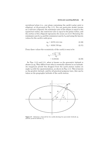
                              meridional plane (i.e., any plane containing the earth’s polar axis) is
                              elliptical, as illustrated in Fig. 2.11. For one particular model, known
                              as a reference ellipsoid, the semimajor axis of the ellipse is equal to the
                              equatorial radius, the semiminor axis is equal to the polar radius, and
                              the surface of the ellipsoid represents the mean sea level. Denoting the
                              semimajor axis by a and the semiminor axis by b and using the known
                                               E
                                                                          E
                              values for the earth’s radii gives
                                                     a   6378.1414 km                    (2.36)
                                                      E
                                                     b   6356.755 km                     (2.37)
                                                      E
                              From these values the eccentricity of the earth is seen to be

                                                               2    2
                                                            2a   b  E
                                                               E
                                                               a E
                                                       e E  5
                                                           0.08182                       (2.38)
                                In Figs. 2.10 and 2.11, what is known as the geocentric latitude is
                              shown as y . This differs from what is normally referred to as latitude.
                                        E
                              An imaginary plumb line dropped from the earth station makes an
                              angle l with the equatorial plane, as shown in Fig. 2.11. This is known
                                    E
                              as the geodetic latitude, and for all practical purposes here, this can be
                              taken as the geographic latitude of the earth station.


                                                         Z                   ES

                                                                           H
                                                                           P
                                                                 R
                                                         b E

                                                                ψ      λ
                                             a E                 E      E
                                                            0


                              Figure 2.11 Reference ellipsoid for the earth showing the geocentric latitude 
 E
                              and the geodetic latitude l E .
   74   75   76   77   78   79   80   81   82   83   84