
Page 84 - Satellite Communications, Fourth Edition
P. 84
64 Chapter Two
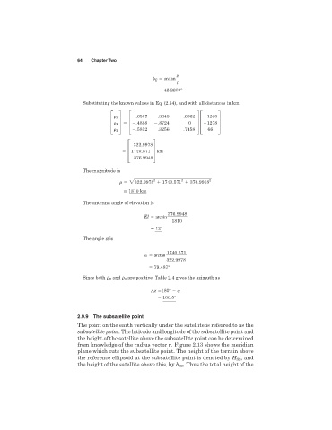
z
E arctan
l
42.2289°
Substituting the known values in Eq. (2.44), and with all distances in km:
.6507 .3645 .6662 1280
S
≥ E ¥ ≥ .4888 .8724 0 ¥≥ 1278 ¥
Z .5812 .3256 .7458 66
322.9978
≥1740.571 ¥ km
376.9948
The magnitude is
2
2
2322.9978 1740.571 376.9948 2
> 1810 km
The antenna angle of elevation is
376.9948
El arcsin
1810
> 12°
The angle a is
1740.571
arctan
322.9978
79.487°
Since both r E and r S are positive, Table 2.4 gives the azimuth as
Az 180°
100.5°
2.9.9 The subsatellite point
The point on the earth vertically under the satellite is referred to as the
subsatellite point. The latitude and longitude of the subsatellite point and
the height of the satellite above the subsatellite point can be determined
from knowledge of the radius vector r. Figure 2.13 shows the meridian
plane which cuts the subsatellite point. The height of the terrain above
the reference ellipsoid at the subsatellite point is denoted by H , and
SS
the height of the satellite above this, by h . Thus the total height of the
SS